Free tools Windows power users keep installed
One-click scans. No signup required.
Some links on this page are affiliate links: if you buy through them we may earn a commission, at no extra cost to you.
Neither satellite embeddings nor raw imagery is universally better. Embeddings are compact, reusable summaries that work especially well for search, clustering, transfer learning, and prediction when labels are scarce. Raw image chips are safer when a model must preserve pixel geometry, fine boundaries, spectral bands, temporal change, cloud context, or acquisition details. For many production systems, the strongest design is hybrid: generate embeddings for indexing and broad screening, then run raw-chip inference on high-value candidates that need precise results or human audit.
What is the difference between a satellite embedding and raw imagery?
A satellite embedding is a numerical feature vector produced by an encoder such as a convolutional neural network or vision transformer. Instead of retaining every pixel, the encoder maps an image patch to a compact representation intended to preserve the characteristics useful for similarity search or downstream prediction. A raw-image pipeline feeds the original pixel arrays, bands, timestamps and other acquisition metadata directly into a model.

As an Amazon Associate I earn from qualifying purchases.
What’s actually slowing this PC down?
Pick the symptom - the matching free tool is one click away.
The distinction is lossy compression versus direct evidence. An embedding can make millions of scenes easy to index and compare, but the encoder decides which signals survive. Raw imagery keeps the evidence available for a later task, at the cost of more storage, bandwidth and encoder computation.
What embeddings contain
Embeddings summarize patterns learned during pretraining. SatCLIP, for example, learns location representations by matching image patterns with geographic coordinates. Its AAAI 2025 paper describes the result as an encoder that “efficiently summarizes the characteristics of any given location for convenient use in downstream tasks.” Such a vector can place visually or geographically related patches near one another even when no task-specific labels are available.
#1 Best Overall

- [Ultra-Lightweight Ear Buds Designed for Small Ears] Each earbud weighs only 3.7g and features a compact, ergonomic in-ear design made especially for small ears. Secure, low-profile, and comfortable for workouts, all-day wear or overnight sleeping.The ultra-slim profile sits flush in your ear with no hard edges poking or rubbing, so you can even sleep on your side without discomfort.
- [Immersive Stereo Sound with TOZO OrigX Technology] TOZO OrigX tuning delivers clear vocals, balanced mids, and natural stereo sound for music, podcasts, and videos.
- [Long Battery Life for Daily Use] Get up to 7 hours of playtime on a single charge, with up to 32 hours total using the charging case—ideal for workdays, commuting, and extended listening sessions.
- [Bluetooth 5.3 & Stable Connection] Bluetooth 5.3 provides fast pairing, stable wireless performance, and reduced dropouts as you move around home or office.
- [Deep Bass with Clear Vocals] High-performance drivers produce punchy bass while keeping vocals clean and detailed for everyday listening.
A vector does not automatically retain a one-to-one map back to every object boundary, wavelength or acquisition condition. The information that survives depends on the encoder architecture, training data, input bands and resolution, pooling strategy and any compression applied after inference.
What raw imagery retains
Raw chips preserve the spatial arrangement of pixels, the original spectral measurements and the temporal and atmospheric context supplied with the scene. That makes them the safer representation for segmentation masks, change maps, physical measurements and any output whose correctness depends on an exact boundary or a particular band combination.
Which representation fits each geospatial AI task?
Choose the representation from the output you must produce, not from the model’s popularity. Vector-level search and broad classification often benefit from embeddings; pixel-level delineation and sensor-sensitive analysis usually require raw inputs or a model that can still access them.
| Task or requirement | Usually favored | Reason |
|---|---|---|
| Nearest-neighbor search, catalog discovery and deduplication | Embeddings | Compact vectors support fast indexes and similarity calculations without repeatedly decoding every image. |
| Clustering and exploratory mapping | Embeddings | Feature spaces expose groups for inspection and label discovery before a full model is trained. |
| Few-label classification or transfer learning | Frozen or lightly adapted embeddings | A small classifier can reuse representations learned from large pretraining corpora. |
| Building or road segmentation | Raw imagery, or a feature map that preserves spatial detail | Thin edges and object geometry can be lost when a patch is reduced to one vector. |
| Land-cover classification with many labeled examples | Benchmark both; raw fine-tuning may win | Task labels and compute can justify learning features specific to the target geography and sensor. |
| Change detection and attribution | Raw, time-aligned imagery | The model needs comparable observations and the temporal signal, not just a static summary. |
| Cloud, haze or atmospheric-condition analysis | Raw multispectral or modality-matched features | Top-of-atmosphere and band information can determine whether the condition is visible. |
| Expert audit of a prediction | Raw imagery alongside embeddings | Analysts can inspect the pixels and acquisition context that support the output. |
When are satellite embeddings the better choice?
Embeddings are the practical default when your first question is “Which scenes resemble this one?” rather than “Which exact pixels form this object?” They reduce repeated encoder work and make large archives manageable.
Search and retrieval at archive scale
In a 2024 IBM Research study, a Prithvi-based multispectral retrieval system achieved 97.62% mean average precision on BigEarthNet-43 and 44.51% on ForestNet-12. The reported accuracy was retained with 32-fold embedding compression. Those figures are benchmark results for the named datasets, not a guarantee for a different sensor, geography or preprocessing pipeline, but they demonstrate why retrieval is a strong embedding use case.
A typical workflow encodes every catalog item once, stores the vectors in a nearest-neighbor index and encodes each query only once. Search then operates on compact numeric data instead of reopening and reprocessing every raw scene.
Clustering, deduplication and weak-label discovery
Unsupervised groups in embedding space can reveal repeated acquisitions, unusual land-cover patterns or mislabeled records. Analysts can inspect a small sample from each cluster, assign labels and use those labels to seed a supervised model. Near-duplicate detection also becomes a vector-distance problem, which is cheaper than comparing every pixel pair in a large archive.
Rank #2

- 【IP68 Waterproof Multifunctinal Smart Watch】Torjalph fitness activity tracker smart watch is IP68 waterproof technology ,you can wear it when swimming,handwashing,it's rain-proof which means that you perform multiple exercise modes outside without worrying about sweat or rain corroding your fitness smart watch,and this watch equipped with a 230 mAh large capacity battery magnetic charging ,and this sports activity tracker watch can be used 5-7 days If fully charged.
- 【Larger 1.83'' Full Screen Watch & Multi-dial Selection】1.83 inch full HD color touch screen smart watch for men / women provides excellent 240*284 resolution image quality ,This Bluetooth smart watch offers a better touch experience and remarkable immersion and ,more than 200 watch faces for you to choose from App"Da Fit ", you can change the dial style according to your mood to wear keeping the world on your wrist
- 【Accurate Activity Tracker Smart Watch 】sports watch activity tracker uses sweat and dust resistant breathable silicone strap, our Fitness Tracker Smart Watch for Android iOS Phones supports 12 sports modes,walking,running,bicycle,swimming,badminton,basketball,football,rope skipping. This bluetooth calls smart watch for men women is lightweight and stylish, bringing more convenient and relaxing sports experience while also providing more protection.
- 【Your 24 Hour Personal Daily Health Monitor】Fitness watch for women men full touch screen IP67 waterproof bluetooth smartwatch for Android iOS Phones with heart rate blood pressure monitor multifunction Andriod smart watch with steps counter sleep monitor sports fitness watch, monitoring blood oxygen saturation allows you to understand your physical condition in real time to track fitness progress ,to know your health status in time.
- 【More Functions Bluetooth Call Smart Watch】This fitness activity smart watch full screen for iPhone and Android phones includes a bunch of new features including:The bluetooth smart watch can hang up the phone, receive and display WhatsAPP /Text /Facebook /Twitter /Messenger reminder.Support sedentary reminder, alarm clock, stopwatch, timer,weather information,music control, remote camera control compatible with Android 5.0 and above or iOS 9.0 and above smartphones.
Few-label transfer learning
When labeled examples are scarce, a frozen encoder plus a linear classifier is an efficient baseline. The classifier learns a small number of parameters while the encoder supplies general features. This is particularly useful for a rapid feasibility test: if a linear probe performs well, the representation already separates the classes enough to justify a larger deployment.
Are embeddings good enough for segmentation and boundary-sensitive work?
Usually not when the final output is a precise mask. A single pooled vector describes a patch but does not inherently specify which pixel belongs to a roof, road or field boundary. Segmentation can use intermediate feature maps or decoder architectures that preserve spatial coordinates, but a generic image-level embedding should not be assumed to contain the detail required for thin or irregular objects.
Why boundaries disappear
Encoders commonly downsample images and aggregate activations. Two patches with different edge geometry can therefore produce similar vectors if their overall texture and context are alike. Compression, pooling and the pretraining objective can further favor broad semantic similarity over exact outlines.
Recommended Free Tools
The PhilEO Bench illustrates the scale of the raw-data problem. Its 2024 IEEE benchmark uses a 400 GB Sentinel-2 dataset for building-density estimation, road segmentation and land-cover classification; the paper notes that Sentinel-2 produces about 1.6 TB of data daily. Those pixel-level tasks require access to image geometry and bands during training and evaluation. An embedding index can help select candidate scenes, but the final mask should be generated from raw chips or spatially detailed features.
When an embedding-assisted segmenter can work
An encoder-decoder model can use embeddings as global context while receiving a higher-resolution feature map or raw bands for local detail. Another practical pattern is two-stage inference: use vectors to identify likely scenes, then run a segmentation model only on those scenes. Validate boundary quality with object-level metrics and visual inspection; a strong image-level retrieval score does not establish mask accuracy.
Do embeddings lose spectral, spatial or temporal information?
They can. Loss is not inevitable, but it is a design risk that must be measured for the specific encoder and task.
- Spectral detail: a model trained on RGB or a limited band set cannot recover distinctions that depend on bands it never received. Even a multispectral encoder may compress subtle band relationships into a representation optimized for its pretraining objective.
- Spatial detail: pooled vectors summarize a patch and may blur small objects, edges and relative positions. Spatially indexed feature maps retain more geometry than one vector.
- Temporal detail: a single-date embedding cannot represent a change sequence unless the encoder was designed and trained for multi-temporal input.
- Atmospheric and acquisition context: clouds, haze, viewing angle and top-of-atmosphere effects can be predictive signals or confounders. Removing them through normalization or compression may hide a condition that matters to the task.
- Metadata: timestamp, sensor, resolution and processing level may not be recoverable from the vector. Keep metadata in the catalog even when vectors are the primary index.
For these reasons, preserve a link from every vector to its source chip, sensor, date, processing level and geographic footprint. That enables a raw-image check when a prediction is surprising or when a model is upgraded.
Quick wins for a faster PC:
Repair Windows errors before they cause bigger problemsFix Now →Scan for outdated or missing drivers - takes under a minuteDriver Scan →Clear out junk files and repair common Windows errorsFree Scan →Rank #3
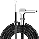
- [Low Noise High Fidelity] New bee guitar cord with 22AWG oxygen-free-copper center conductors provides enhanced signal transfer, the PVC insulation material and the high-density stranded copper double shield provide noise rejection for quiet operation
- [Ideal for Choice] New bee 1/4 straight and right angle metal connectors, ensures a secure connection in any instrument, pedal, or amp jack. L shape great fro on stage guitar stands
- [Wide Compatible] Suitable for mixer, power amplifier, microphone, effector, decoder, equalizer, electoronic organ, electric guitar, electric bass and other electronic equipments. Widely used in the installation of smart home, karaoke speaker, professional stage audio, etc
- [Easy Disassemble] Making incidental repairs quick and easy! Very nice, flexible cable
- [Dont Hesite to Order] 24 hours customer services and professional technology team are standing by
How do sensor and atmosphere requirements change the choice?
Use a representation trained on the same kinds of bands, resolution, geography, season and cloud regime as deployment. A model trained on one modality can produce plausible-looking vectors for another modality while silently discarding the signal you need.
SatVision-TOA is a concrete example of modality-specific design. Its 2024 system uses 14-band MODIS top-of-atmosphere data, 100 million training images and 3 billion parameters. On cloud retrieval it reports mean intersection-over-union of 0.46 versus 0.22 for a baseline. The result does not mean a 3-billion-parameter model is required for every project; it shows that retaining the relevant top-of-atmosphere bands and training at scale can materially change performance.
Before selecting an encoder, make a checklist of the deployment stream: sensor and band names, ground-sample distance, projection, revisit interval, seasonal distribution, cloud and haze frequency, and whether values are top-of-atmosphere or surface reflectance. If a pretrained model does not match those characteristics, compare it with raw-image fine-tuning or adaptation rather than assuming the vector is interchangeable.
Should you use frozen features, parameter-efficient adaptation or full fine-tuning?
Test the least expensive adaptation first, but move toward raw-image fine-tuning when the task or domain gap demands it. A frozen embedding is a baseline, not a verdict on the foundation model.
Frozen encoder and linear probe
Generate vectors once, train a linear classifier or small regressor, and record performance by geography and time. This setup is fast and reproducible, and it reveals whether the representation is useful without changing the encoder.
Parameter-efficient self-supervised adaptation
When the frozen baseline is close but not sufficient, adapt a small portion of the encoder. A CVPR 2024 study by Scheibenreif, Mommert and Borth reports 4–6 percentage-point gains in linear evaluation across eight datasets and 6–10-point gains in few-shot accuracy while training only 1–2% of model parameters. These are aggregate results from that study; your improvement will depend on the sensor, labels and adaptation data.
Full fine-tuning on raw inputs
Use full fine-tuning when you have enough representative labels and compute, or when the output requires information the frozen vector discards. Keep the pretraining weights as an initialization, but allow convolutional or transformer layers to learn the target bands, spatial scale and temporal context. Compare against the adapted and frozen baselines under the same data split and compute budget.
Rank #4

- Digital Family Calendar: BSIMB digital calendar wall touch screen puts an end to your chaotic life. Designed for busy families, the digital calendar keeps you organised and in step with your family. Assign different colours and tasks to each family member to make family scheduling easier and more intuitive.
- Easy Setup and Auto-Sync: Plug in, connect to WLAN and auto-syn your electric calendar in minutes. Digital wall calendar compatible with Google calendar, iCloud calendar, Outlook calendar, Cozi calendar and Yahoo calendar. Add events directly on the device or through the ecalendar app. Electronic calendar stays current whether you're at work or traveling—no manual updates needed.
- All-In-One Home Assistant: Smart calendar builds habits and encourage independence with personalised chores. Display daily meal plan to reduce the daily ‘What's for dinner?’ stress. To-do lists keep track of everything you want. Turning chores into valuable achievements with stars and rewards, making life easier and more enjoyable.
- Manage Anytime Anywhere: BSIMB electronic calendar for family stay connected with the powerful ecalendar app. Access and manage your digital wall calendar anytime, anywhere with free features like stars & rewards, photo screensaver, chore charts, meals plans, to-do lists etc. Electronic planner paid features like Magic Import tailor advanced tools for users with special needs.
- Stay in Touch with Loved Ones: Share photos or videos from your phone to electronic wall calendar with app, instantly update your life moment, and keep in touch with your family, especially those who are far away; you can also surprise your smart calendar digital wall by sending him a wish card; it's also great for keeping tech-illiterate elders in touch with the youngsters.
What does a fair evaluation look like?
A single random split can make a geospatial model look better than it is because nearby or same-date tiles leak into both training and test sets. Build a validation design that mirrors deployment.
Windows Errors? Fix Them Before They Spread
Repair common Windows errors and clear accumulated junk for a smoother, more stable PC - no reinstall needed.Free scan · no reinstallOutdated Drivers Are Slowing You Down
One free scan finds every outdated or missing driver and matches the right update for your exact hardware.Free scan · exact hardware match- Assemble a representative raw-image set. Include the sensors, resolutions, seasons, cloud conditions and geographies you expect to serve. Keep the source metadata attached to every chip.
- Split by geography and time. Hold out regions and dates, not just random pixels. If the product will move between sensors, hold out at least one sensor or acquisition condition for a stress test.
- Generate frozen embeddings once. Record the encoder version, preprocessing, band order, projection and vector dimensionality so the experiment can be reproduced.
- Run three baselines. Evaluate a linear probe, nearest-neighbor retrieval and a simple downstream model on the vectors. Measure the task metric that matches the product, not only overall accuracy.
- Train a raw-image baseline. Use the same labels, geographic split, augmentation policy and compute accounting. For segmentation, report boundary or object metrics in addition to pixel averages.
- Test parameter-efficient adaptation. Adapt 1–2% of parameters or the method appropriate to the encoder, then rerun the same held-out tests.
- Break out failure modes. Report results by sensor, geography, season, resolution and cloud condition. Aggregate scores can hide a severe domain failure.
- Inspect disagreements. For false positives and false negatives, open the raw chip and compare it with the nearest embedding neighbors. This often reveals a band mismatch, cloud artifact or label ambiguity.
What is the recommended hybrid architecture?
A hybrid pipeline uses each representation where it is strongest and limits expensive raw processing to cases that justify it.
- Ingest and normalize raw scenes. Preserve the original chip, band metadata, acquisition time, footprint and processing level.
- Encode the archive. Produce vectors with a fixed model and store a stable reference from each vector to its raw source.
- Build operational indexes. Use vectors for nearest-neighbor search, deduplication, clustering and broad triage. Keep sensor and date filters outside the vector distance so incompatible observations are not compared blindly.
- Discover candidates. Retrieve similar scenes, identify clusters for labeling or flag patches likely to contain the target condition.
- Route high-value cases to raw inference. Run segmentation, change attribution, spectral-index analysis or expert review on the original chips.
- Record provenance. Store the encoder version, raw-scene identifier, preprocessing settings, model version and confidence with every prediction.
- Monitor drift. Track vector distributions and raw-image metrics separately by sensor, geography and season. Re-encode when the encoder or preprocessing changes.
This design keeps the catalog responsive while preserving an auditable path back to the evidence. It also lets you replace the downstream raw model without rebuilding the entire search index, provided the embedding contract remains stable.
How do storage, speed and auditability compare?
| Operational factor | Embedding pipeline | Raw-image pipeline |
|---|---|---|
| Archive footprint | Compact vectors plus metadata; the IBM study retained reported retrieval accuracy with 32-fold compression. | Large raster storage; the PhilEO benchmark alone is 400 GB, while Sentinel-2 production is cited at about 1.6 TB per day. |
| Query latency | Fast nearest-neighbor search after one-time encoding. | Requires reading and often re-encoding candidate imagery for each model or query. |
| Model flexibility | Several lightweight heads can reuse one vector set, but new tasks may require a new encoder. | New models can use any retained bands and spatial context, at the cost of more compute. |
| Explainability | Needs neighbor retrieval, saliency or another visualization to connect a score to imagery. | Analysts can inspect the original pixels, bands and acquisition conditions directly. |
| Reprocessing cost | Low for new linear heads; high if the encoder or preprocessing changes and all vectors must be regenerated. | Higher per inference, but no separate embedding rebuild is required. |
Compression is not free. Keep enough raw data, or a governed retention tier, to reproduce important decisions. A vector-only archive may be adequate for exploratory search but insufficient for regulated workflows, scientific reanalysis or disputes over a boundary.
What common failure modes should you troubleshoot?
High retrieval scores but poor segmentation
Check whether the retrieval benchmark measures patch similarity while the product requires pixel boundaries. Add a spatially detailed decoder or route the candidates to raw-chip segmentation, then evaluate object and edge quality.
The Tool Desk
Outbyte PC Repair FREERepair Windows errors before they cause bigger problemsFix Now →Outbyte Driver Updater FREEScan for outdated or missing drivers - takes under a minuteDriver Scan →Performance collapses on a new sensor
Compare band definitions, ground-sample distance, radiometric scaling and preprocessing. If the encoder never saw the new modality, use a modality-matched model or adapt it with unlabeled and labeled target data.
Cloudy scenes dominate nearest neighbors
Inspect whether the embedding learned atmospheric appearance as the strongest similarity cue. Add cloud-condition filters, include representative clear and cloudy examples during adaptation, and retain raw inspection for ambiguous matches.
Results vary by region or season
Break out metrics by geography and time instead of relying on one aggregate. Add held-out regional and seasonal data, then decide whether parameter-efficient adaptation or raw fine-tuning is needed.
Analysts cannot explain a vector prediction
Store the source-chip identifier and retrieve nearest raw neighbors for every decision. If that evidence is still inadequate, make raw inference the production path for the affected task.
Do these 3 things before closing this tab:
1Clear out junk files and repair common Windows errors2Fix the driver behind crashes, sound loss and screen glitches3Repair Windows errors before they cause bigger problemsEmbedding indexes become inconsistent
Pin the encoder, band order, normalization and dimensionality. When any of those change, version the index and re-encode the affected archive rather than mixing incompatible vectors.
What do the major studies imply for model selection?
| Study or system | Evidence | Practical implication |
|---|---|---|
| SatCLIP (AAAI 2025) | Coordinates and image patterns are matched to learn reusable location representations; improvements were reported across nine geospatial prediction tasks. | Useful general-purpose location features, especially when labels are limited, but still a summary representation. |
| PhilEO Bench (IEEE, 2024) | 400 GB Sentinel-2 benchmark for building-density estimation, road segmentation and land-cover classification; Sentinel-2 is cited at 1.6 TB daily. | Pixel-level benchmarks justify retaining raw geometry and bands for final inference. |
| Prithvi retrieval (IBM Research, 2024) | 97.62% mAP on BigEarthNet-43 and 44.51% on ForestNet-12; 32-fold compression retained reported accuracy. | Strong evidence for compact multispectral retrieval indexes, subject to dataset and sensor qualification. |
| Parameter-efficient adaptation (CVPR, 2024) | 4–6-point linear-evaluation gains across eight datasets and 6–10-point few-shot gains while training 1–2% of parameters. | Adaptation can close a domain gap without the cost of full fine-tuning. |
| SatVision-TOA (2024) | 14-band MODIS top-of-atmosphere input, 100 million training images and 3 billion parameters; cloud-retrieval mIoU 0.46 versus 0.22 baseline. | Atmospheric modality and scale matter; do not treat all satellite embeddings as interchangeable. |
| SSL4EO-L (NeurIPS, 2023) | Self-supervised learning corpus containing 5 million Landsat image patches. | Large remote-sensing pretraining can provide reusable features, but target-sensor validation remains necessary. |
A GeoAI review cautions that “the multimodal nature of geospatial tasks hinders a straightforward application of existing pre-trained FMs across all GeoAI tasks.” In practice, there is no universal geospatial foundation model: match the representation to the modality and output, then validate it on the deployment split.
Frequently Asked Questions
Can I delete the original satellite images after creating embeddings?
Only if your use case is limited to non-audited search and you accept that future tasks may need information the vectors discarded. For scientific, regulated or boundary-sensitive work, retain the source chips or a governed archive and keep a persistent identifier in the vector index.
How often should a satellite embedding index be regenerated?
Regenerate it whenever the encoder weights, band order, radiometric normalization, projection or chip size changes. New imagery can be encoded incrementally, but mixing vectors made with incompatible preprocessing can corrupt similarity rankings.
Which metric should I use to compare embedding and raw-image models?
Use the metric tied to the product output: mean average precision for retrieval, intersection-over-union and boundary measures for segmentation, and class-specific scores for imbalanced classification. Always report those metrics by sensor, geography, season and cloud condition as well as in aggregate.
Can one embedding model serve optical and radar imagery?
Do not assume it can. Optical and radar have different measurement physics and artifacts; use a model trained for the relevant modality or demonstrate through held-out tests that a shared representation preserves the signals your task needs.
Quick Recap
Product prices and availability are accurate as of the date/time indicated and are subject to change. Any price and availability information displayed on Amazon at the time of purchase will apply.

