Outdated Drivers Are Slowing You Down
One free scan finds every outdated or missing driver and matches the right update for your exact hardware.Free scan · exact hardware matchPC Slower Than It Used to Be?
A free scan shows the junk files, broken settings and background clutter dragging Windows down - then fixes them in one click.Free scan · Windows 10 & 11Some links on this page are affiliate links: if you buy through them we may earn a commission, at no extra cost to you.
Choose SAR when the primary problem is seeing through darkness, cloud, smoke, dust, or wide areas; choose EO/IR when the primary problem is understanding exactly what a target is. Synthetic-aperture radar (SAR) actively illuminates the scene with microwaves, while electro-optical/infrared (EO/IR) systems use reflected visible light, low-light signals, or emitted heat. SAR therefore supplies persistent detection and structural change evidence in conditions that defeat ordinary cameras. EO/IR usually gives people more intuitive visual detail, color, thermal contrast, and identification cues when visibility is adequate. A fused SAR-plus-EO/IR payload is often the most capable design when the platform, bandwidth, processing, and budget can support two independent sources of information.
The right answer is mission-specific rather than a universal sensor ranking. Start by deciding whether you need detection, tracking, recognition, classification, or identification; then account for illumination, clouds, fog, smoke, target material, coverage area, revisit frequency, and analyst workflow.
As an Amazon Associate I earn from qualifying purchases.
What do SAR and EO/IR actually measure?
SAR and EO/IR are not interchangeable cameras. They respond to different physical properties, so the same object can look prominent in one modality and nearly disappear in the other.
How SAR forms an image
Synthetic-aperture radar transmits its own microwave energy and records the strength and timing of returned echoes, called backscatter. By combining measurements collected as the sensor moves, processing creates a high-resolution image over a large ground area. Because the system supplies its own illumination, it does not depend on sunlight. NOAA describes SAR imagery as independent of time of day and capable of imaging through clouds at typical radar frequencies. NASA’s Jet Propulsion Laboratory likewise notes that imaging radar can operate at any time and that longer wavelengths can pass through cloudy and dusty conditions that visible and infrared instruments cannot.
#1 Best Overall

- 【Enhanced Thermal Clarity】Start with 128x128 thermal imaging and enhance to 240x240 resolution with TISR technology for greater details. The wide 40°x 30° field of view and a 25Hz refresh rate deliver accurate, smooth thermal images—ideal for detailed inspections in homes and on electrical systems and machinery
- 【Wide Application with Smart Alerts and Photograph】From underfloor heating to leak detection and electrical inspections, the TC004 Mini adapts to every challenge. When temperatures exceed preset levels, an on screen warning alerts you instantly while automatically capturing a photo to streamline your diagnostics. In addition, TC004 Mini also supports manual photo taking to help you record and solve problems, and the built-in 512MB eMMC storage can store up to 8,000 photos
- 【Effortless Temp Measurement with Alerts】Easily measure temperatures between -4°F to 842°F (-20°C to 450°C), with an accuracy error within ±3.6°F/2%, the thermal camera automatically pinpointing the highest, lowest, and central spots. Plus, you can choose from 5 different color palettes - White Hot, Black Hot, Iron, Rainbow, and Red Hot - to meet your specific work needs. Instant warnings will alert you when the temperature exceeds your preset level, making your job more efficient
- 【Longer Runtime, Fewer Charges】Designed for efficiency, this thermal imaging camera gives you 15 hours of power and automatic shut-off options at 5, 10, and 20-minute intervals to extend battery life. Keep going without the hassle of frequent charging, no matter how long your inspections last. A charging cable is given with the machine, but no charging head.
- 【Portable, Durable & Hassle-Free】Take this thermal imaging camera anywhere with its mini, pocket-friendly design. The ergonomic design makes it easier for you to hold during use, and the lightweight design is more suitable for long-term use. Engineered for durability, it can survive drops up to 2 meters without skipping a beat. Supports IP54 waterproof rating to ensure worry-free daily use. Get peace of mind with TOPDON's lifetime technical support to keep it running smoothly
Radar brightness is not a photograph’s brightness. It changes with surface roughness, moisture, geometry, polarization, wavelength, and dielectric properties. A smooth wet surface may return little energy and look dark, while a rough structure or corner reflector can appear very bright. Vegetation, soil, ice, buildings, and vehicles each produce characteristic responses, but interpreting those responses requires training and contextual information. Speckle graininess and geometric effects such as layover and shadow are normal parts of many SAR images.
How EO/IR produces an image
EO/IR is a family of sensors rather than one band. It can include visible light, low-light or near-infrared channels, and infrared bands from short-wave through long-wave infrared. The Office of Naval Research describes EO/IR programs built for real-time detection, tracking, classification, and identification of air, sea-surface, and ground targets.
Visible electro-optical cameras record reflected sunlight or artificial light, producing the familiar color and shape cues people use naturally. Thermal infrared cameras measure emitted radiation from objects themselves, so they can work without an external light source. Thermal contrast may reveal a person, a warm engine, a fire, or recently disturbed ground, but the useful signal depends on the temperature difference between target and background and on atmospheric transmission.
When does SAR work best?
SAR is usually the first choice when persistence, area coverage, or all-weather access matters more than instantly familiar imagery.
Persistent day-and-night monitoring
A SAR collects its own illumination, so darkness does not remove the scene. It can support repeated surveillance of coastlines, borders, infrastructure corridors, flood zones, or remote terrain on a schedule that does not have to wait for daylight. NASA/JPL summarizes this advantage by noting that radar can image at any time of day or night regardless of solar illumination.
Cloud, haze, smoke, and dust
Microwave wavelengths are generally less affected by clouds than visible light and can remain useful through conditions that obscure an optical camera. Longer radar wavelengths can also see through dusty or smoky conditions that block visible and some infrared channels. This does not mean every storm is transparent: heavy precipitation, wet radomes, extreme turbulence, unfavorable viewing geometry, and low signal-to-noise ratios can still degrade a collection.
Do these 3 things before closing this tab:
1Fix the driver behind crashes, sound loss and screen glitches2Clear out junk files and repair common Windows errors3Scan for outdated or missing drivers - takes under a minuteBroad-area mapping and change detection
SAR is efficient for mapping large regions and comparing acquisitions over time. Changes in roughness, moisture, structure, or geometry can expose flooding, soil disturbance, construction, landslides, shoreline movement, deforestation, or damage to built infrastructure. Interferometric techniques can measure surface deformation when acquisitions, geometry, and coherence are suitable, although a single image should not be treated as a deformation measurement.
Surface, ice, and maritime applications
Sandia National Laboratories lists environmental monitoring, earth-resource mapping, oil-spill boundaries, sea-state and ice-hazard maps, reconnaissance, and targeting among SAR applications. On water, wind-driven roughness, slicks, vessels, and ice textures can create useful contrasts. Analysts still need to account for sea state, incidence angle, polarization, and look direction before assigning an object or boundary a confident label.
Rank #2

- 【Dual Mode Inspection】Combines conventional thermal imaging (Center/Hot/Cold spot modes) with thermometer mode for flexible temperature analysis. Use full-screen thermal imaging to monitor moving animals, machinery, automotive, or HVAC systems in real time, ensuring continuous observation with no detail loss. When you need exact numbers such as kitchen use, thermometer mode provides quick, point-and-shoot readings with a clear digital display.
- 【User-Friendly Operation】Weighing just 240g, this compact thermal imager offers a balanced feel with a non-slip grip even during extended use. Intuitive button controls let you power on, navigate menus, capture images, and switch between seven color palettes effortlessly—so you can start inspecting right away.
- 【Multi-Scenario Application】Built with high-precision sensors (NETD < 50mK), it detects subtle temperature differences down to 0.05°C. The -4°F to 1022°F temperature range handles everything from household inspections to high-heat diagnostics, including home kitchens, insulation checks, and automotive maintenance.Adjustable emissivity and distance settings help improve accuracy across materials like cement, ceramic,etc.
- 【Fast Anomaly Detection with Instant Alerts】A 50° wide field of view lets you scan larger areas in less time. Set custom high and low temperature alarms for instant alerts when temperatures exceed your limits. Adjustable level and span settings enhance thermal contrast, making it easier to identify issues such as insulation gaps and floor heat loss.
- 【All-Day Battery Life 】The built-in 2500mAh rechargeable battery provides up to 14 hours of continuous use for uninterrupted inspections. Backed by a 1-year warranty for added peace of mind.
Vegetation and shallow penetration
Depending on wavelength and conditions, radar can penetrate vegetation canopy and interact with soil or other surfaces below it. NASA training material lists penetration through vegetation canopy and soil as a radar advantage. The amount of penetration is not fixed: wetter vegetation, denser canopy, wavelength, and viewing geometry all change the result.
When is EO/IR the better choice?
EO/IR generally wins when an operator must recognize a target quickly, inspect fine visual detail, or exploit color and heat signatures in conditions with adequate atmospheric visibility.
Visible EO for familiar detail
Visible cameras preserve shape, color, textural detail, and context in a way that most people can interpret immediately. They are valuable for close inspection, documenting damage, reading markings, distinguishing equipment by appearance, and confirming a radar cue. Their weakness is illumination and atmospheric visibility: the National Weather Service notes that visible satellite imagery depends on sunlight and appears dark at night.
Thermal IR for heat contrast
Thermal cameras detect emitted energy rather than reflected sunlight, allowing operation at night. A warm vehicle against a cool background, a person, an active fire, or recently disturbed material may stand out even when a visible camera sees little. Thermal imagery can lose detail when the target and background approach the same temperature, after surfaces have thermally equilibrated, or when clouds, precipitation, humidity, and atmospheric absorption attenuate the signal. The Hong Kong Observatory explains both the night-time advantage of emitted-energy imaging and the fact that visible imagery can retain details thermal imagery does not.
Tracking, classification, and identification
EO/IR systems are designed around a human-readable chain from detection to tracking, classification, and identification. A visible image may show whether a vehicle is a truck, boat, or excavator; thermal channels may reveal whether it is running. Combining bands can improve confidence, but the result remains dependent on range, resolution, atmospheric conditions, stabilization, and the quality of the processing pipeline.
How do darkness, clouds, fog, smoke, and rain change the choice?
There is no single “night sensor” or “bad-weather sensor.” Each condition affects the modalities differently, and the target’s contrast matters as much as the weather report.
What’s actually slowing this PC down?
Pick the symptom - the matching free tool is one click away.
| Condition or need | Typical advantage | Important qualification |
|---|---|---|
| Complete darkness | SAR or thermal IR | SAR supplies microwave illumination; thermal IR uses emitted heat. Visible EO needs sufficient artificial or natural light. |
| Cloud cover | SAR | Microwave imaging is generally more cloud-resilient. Very heavy precipitation and system-specific geometry can still reduce quality. |
| Fog | Usually SAR; thermal performance varies | Visible contrast can collapse. Infrared transmission depends on band, droplet size, humidity, and path length. |
| Smoke or dust | Longer-wavelength SAR | Longer wavelengths can penetrate conditions that defeat visible and some IR channels, but severe obscurants are not guaranteed to be transparent. |
| Warm target at night | Thermal IR | Detection depends on target-background temperature difference and atmospheric transmission. |
| Fine color or markings | Visible EO | Requires illumination and sufficient visibility; color is not preserved by SAR and may not be meaningful in thermal imagery. |
| Persistent change mapping | SAR | Backscatter responds to structure, roughness, moisture, and dielectric properties; interpretation needs suitable reference data. |
Is radar better than EO/IR at night?
Radar is more reliable for obtaining a scene at night, but “better” depends on the task. SAR can continue mapping broad areas with no ambient light. Thermal IR can reveal heat signatures and may be excellent for finding people, engines, or fires. Visible EO can provide superior recognition when the scene is artificially illuminated. For a mission that must first find a change and then identify it, SAR for detection followed by EO/IR for confirmation is often more effective than forcing one sensor to perform both jobs.
What is the difference between detection, recognition, classification, and identification?
Sensor selection becomes clearer when the required decision is stated precisely.
Rank #3

- 【Enhanced Thermal Clarity for Precise Inspections】The RT280 handheld thermal imaging camera features a 2.8-inch 320×240 LCD screen for smooth, detailed thermal visuals. Equipped with TISR technology, it enhances thermal image effective resolution from 120×90 to 240×180, enabling the capture of tiny temperature differences. Its 50°x 38° FOV and 25Hz frame rate deliver clear, smooth images, making it ideal for home inspections, electrical checks, mechanical fault diagnosis, and automotive engine inspections.
- 【Smart PC Analysis with 2D/3D & Temperature Insights】Easily transfer images from this thermal imager to Windows PC(Not compatible with Mac) for advanced analysis. The included software supports point, line, and area temperature analysis, 2D/3D thermal imaging, and automatic report generation. Complex thermal data from this infrared cameras thermal imaging device is instantly transformed into actionable, shareable insights, helping you solve problems efficiently and professionally.
- 【Built-in 8GB eMMC Storage for Over 20,000 Images】Capture and store more than 20,000 images and videos with this thermal camera, preserving every detail of your inspections. The 8GB eMMC storage ensures all critical thermal imaging data is saved securely and easily accessible. Whether documenting electrical panels, HVAC systems, or machinery, your ir camera keeps all inspection records organized and ready for analysis.
- 【Accurate Temperature Measurement with Smart Alerts】Measure temperatures from –4°F to 1022°F with ±3.6°F / ±2% accuracy. The RT280 thermal imaging camera automatically detects the highest, lowest, and central temperature points. High/low alarms instantly alert you to anomalies, making it easy to prevent overheating, insulation gaps, or mechanical faults. Clear visual and auditory warnings improve efficiency and safety in every inspection.
- 【9 Color Palettes, Laser Targeting & LED Light】Switch between 9 color palettes to visualize subtle temperature differences with clarity. The built-in laser pointer and LED light allow precise targeting in dark or confined spaces. This infrared camera makes it easy to locate hotspots, leaks, or irregular temperature patterns, delivering professional-grade thermal imaging for electrical, HVAC, plumbing, or mechanical diagnostics.
- Detection: establishing that something of interest is present. SAR’s wide-area coverage and weather resilience are valuable here.
- Tracking: maintaining a target’s position or movement over time. Either modality can contribute, depending on revisit rate, field of view, and contrast.
- Recognition: determining the general type or behavior, such as vessel, truck, fire, or flooded field. EO/IR often supplies more intuitive cues, while SAR adds structure and change evidence.
- Classification: assigning a target to an operational or technical category using multiple observable features.
- Identification: establishing the specific object or identity with enough detail for the mission’s decision standard. Visible and thermal imagery are commonly easier for human confirmation, but they still require adequate resolution, range, and atmospheric conditions.
A high-resolution image does not automatically meet an identification requirement. Geometry, motion blur, atmospheric path, target aspect, and processing quality can matter more than nominal pixel count.
Which sensor should a mission choose?
Use this sequence before selecting hardware or imagery subscriptions. It prevents a clear-weather demonstration from becoming an unreliable operational design.
Quick wins for a faster PC:
Repair Windows errors before they cause bigger problemsFix Now →Fix the driver behind crashes, sound loss and screen glitchesFind Drivers →Clear out junk files and repair common Windows errorsFree Scan →- Define the decision. Write down whether the system must detect changes, cue an operator, track movement, classify objects, or identify specific equipment. Set the minimum confidence and response time for that decision.
- List the environmental constraints. Record expected darkness, cloud frequency, fog, smoke, dust, precipitation, humidity, vegetation, terrain relief, and sea state. Use seasonal conditions rather than a single favorable day.
- Describe the target’s physical signature. Note whether success depends on shape, color, markings, heat, roughness, moisture, deformation, motion, or material. SAR responds to backscatter properties; thermal IR responds to emitted energy; visible EO responds to reflected light.
- Set the area and revisit requirement. Broad-area, repeated monitoring favors SAR collection patterns that can cover large regions. Close inspection of a small scene may favor a stabilized EO/IR turret or camera. Make sure the platform can revisit at the required interval.
- Check geometry and resolution. Radar look direction, incidence angle, polarization, layover, and shadow can hide or distort features. EO/IR needs sufficient line of sight, stabilization, focal length, and atmospheric clarity. Validate the worst viewing geometry, not only the best case.
- Plan the analyst workflow. SAR products may require speckle handling, terrain correction, co-registration, and contextual layers. EO/IR operators may need image enhancement, thermal calibration, and continuous tracking. Include training and time-to-decision in the design.
- Decide whether one modality leaves an unacceptable blind spot. If cloud outages would interrupt the mission or visual confirmation is essential after a radar alert, specify a fused architecture or a tasking relationship between sensors.
What are SAR’s main limitations?
SAR’s strengths come with interpretation and collection trade-offs.
- It is not a conventional photograph. Bright and dark areas represent radar interaction, not familiar color or visible brightness. Similar-looking objects can have different returns, and visually obvious objects may be weak in a particular geometry.
- Speckle adds grain. Speckle is a coherent-imaging effect that can obscure small contrasts. Filtering can improve readability but may remove detail or blur boundaries.
- Terrain creates geometric distortions. Slopes can produce layover, foreshortening, and radar shadow. A feature hidden in shadow cannot be recovered from that look angle.
- Moisture and surface state change the answer. Rain, wet soil, crop growth, wind-roughened water, and changing dielectric properties can alter backscatter independently of the event being monitored.
- Analysis needs context. Reliable interpretation often combines digital elevation data, optical imagery, weather records, polarization, multiple dates, and trained analysts.
NASA training material identifies near-all-weather operation, day/night capability, canopy and soil penetration, minimal atmospheric effects, and sensitivity to dielectric properties and structure as advantages, while also noting difficult interpretation, speckle, and topographic effects as disadvantages.
What are EO/IR’s main limitations?
EO/IR delivers intuitive imagery, but its visibility can be fragile.
- Visible EO needs light. Night, deep shadow, and backlighting reduce useful detail unless artificial illumination or a low-light channel is available.
- Atmosphere matters. Clouds, fog, haze, smoke, dust, precipitation, and long slant ranges scatter or absorb energy. The effect differs by infrared band, so a sensor advertised as “IR” is not automatically all-weather.
- Thermal contrast can vanish. A target and its background may reach similar temperatures, especially after sunset, under overcast conditions, or after prolonged exposure to the same environment.
- Heat is not identity. A thermal hotspot can indicate an engine or person but may not reveal color, markings, construction details, or the exact object type.
- Coverage and persistence can be limited. Narrow fields of view, gimballed pointing, line-of-sight blockage, and the need to revisit a target can reduce area efficiency compared with a wide-area radar collection.
When does a fused SAR and EO/IR architecture make sense?
Fusion is most useful when each modality answers a different part of the same operational question. SAR can maintain a broad-area watch and flag a structural or moisture change; EO/IR can then be tasked to inspect the cue, provide color or heat context, and support recognition.
Fusion can occur at several levels. At the data level, co-register images from the same area and time. At the feature level, combine indicators such as a radar change, a thermal hotspot, and a visible shape. At the decision level, let independent detections raise or lower an alert score. The system must preserve timing, geolocation accuracy, sensor calibration, and uncertainty so that a crisp-looking overlay does not create false confidence.
Independent sensors also provide graceful degradation. Cloud cover may remove visible detail while SAR remains available; a radar shadow or ambiguous backscatter pattern may be resolved by an EO/IR look from another angle. The trade-offs are additional payload mass, power, data bandwidth, processing, synchronization, maintenance, and analyst training. Fusion is therefore a design choice, not an automatic requirement for every platform.
Rank #4
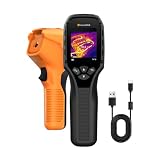
- 【Dual Mode Inspection】Combines thermal imaging with Center/Hot/Cold spot modes for real-time visual temperature display, and integrates thermometer mode for fast point-and-shoot readings with precise digital output. Full-screen thermal imaging enables continuous monitoring of moving targets,ensuring stable observation without loss of detail during dynamic inspections.
- 【User-Friendly Operation】 At just 240g, this compact thermal imager features a non-slip grip and balanced handheld design for comfortable long-duration inspections or mobile use. It offers intuitive button controls for power on/off, menu navigation, and image capture, and supports 7 selectable color palettes, enabling fast switching.
- 【Multi-Scenario Application】It supports a broad measurement range from -4°F to 1022°F with enhanced with adjustable emissivity and distance settings,making it suitable for applications.Equipped with a high-sensitivity sensor (NETD < 50mK), the thermal camera can detect extremely subtle temperature differences as small as 0.05°C.
- 【Quick Anomaly Detection with Alerts 】Featuring a 50° wide field of view, the device enables faster scanning of large surfaces and broader inspection coverage. It supports custom high/low temperature alarms for instant notification when abnormal thermal conditions are detected. Level and span adjustment functions make it easier to clearly identify localized issues.
- 【All-Day Battery Life】Built-in 2500mAh rechargeable battery provides up to 14 hours of continuous operation, supporting full-day inspection without frequent recharging. The device also includes a 1-year warranty, ensuring long-term reliability and peace of mind for using.
Which sensor fits common mission scenarios?
| Mission scenario | Primary starting point | Reasoning and likely complement |
|---|---|---|
| Map flood extent under persistent cloud | SAR | Microwave imaging can acquire through cloud and reveal changes in surface backscatter. Visible or thermal imagery can add context when skies clear. |
| Inspect a bridge or plant for visible damage | Visible EO | Fine shape, color, and surface detail are easiest to interpret directly. SAR change products can cue areas for inspection. |
| Find people or running vehicles at night | Thermal IR, often with SAR support | Heat contrast can expose targets without sunlight; SAR can maintain wider-area coverage and provide movement or structural context. |
| Monitor sea ice and hazardous leads | SAR | Radar supports broad-area ice texture and boundary mapping in darkness and cloud. EO/IR can aid visual confirmation in clear weather. |
| Detect new construction or ground disturbance | SAR time series | Backscatter and, where suitable, interferometric measurements reveal structural or surface change. EO/IR helps classify what was built. |
| Confirm the type of an aircraft, vessel, or vehicle | EO/IR | Visible and infrared bands provide recognition and classification cues. SAR may supply an initial cue when weather blocks the optical view. |
| Operate through changing weather with high consequence decisions | Fused SAR plus EO/IR | Independent signatures reduce blind spots, provided the system can support the extra power, bandwidth, processing, and training. |
How should operators interpret and task each sensor?
Sensor performance is partly an analyst-workflow problem. A practical sequence is to use SAR for broad-area screening or change detection, rank alerts with historical and contextual data, and task EO/IR only where visual or thermal confirmation can change the decision. The reverse can also be appropriate: an EO/IR operator may request SAR when clouds, smoke, or night remove confidence.
For SAR, preserve acquisition geometry, polarization, wavelength, terrain correction, and acquisition time in the product record. Compare like with like before declaring change. For EO/IR, record the spectral channel, focus, stabilization state, atmospheric conditions, viewing angle, and whether a thermal contrast is persistent or transient. A confidence label should state whether the evidence supports detection, recognition, classification, or identification.
The Tool Desk
Outbyte PC Repair FREEClear out junk files and repair common Windows errorsFree Scan →Outbyte Driver Updater FREEScan for outdated or missing drivers - takes under a minuteDriver Scan →What mistakes cause poor sensor choices?
- Treating “all-weather” as absolute. SAR is more weather-resilient than visible EO, not immune to every precipitation or geometry problem.
- Assuming every IR image is thermal. Near-IR reflected light behaves more like visible imagery; thermal IR measures emitted energy. Specify the band and the physical signal.
- Using a single image to prove change. SAR backscatter can vary with moisture, roughness, and viewing conditions. Establish a comparable baseline and inspect contextual data.
- Choosing by marketing resolution alone. Resolution cannot fix radar shadow, cloud obscuration, poor thermal contrast, motion blur, or insufficient revisit time.
- Ignoring human factors. An analyst who can interpret a visible image instantly may need additional training for SAR speckle, layover, polarization, and terrain effects.
- Forcing one sensor to perform every task. Detection and identification often have different environmental and spatial requirements. A cueing relationship or fused design may be more reliable than a single compromise sensor.
What is the practical verdict?
If the mission fails when darkness, cloud, smoke, or broad-area change hides the scene, start with SAR. If it fails when operators cannot recognize fine detail, color, markings, or heat differences, start with EO/IR. When both failure modes matter, combine them deliberately: let SAR provide persistent detection and change evidence, and let EO/IR provide visual or thermal confirmation and classification.
Frequently Asked Questions
Can SAR detect objects under vegetation?
Sometimes. Radar penetration through canopy depends on wavelength, vegetation density, moisture, polarization, and viewing geometry, so a canopy does not guarantee either visibility or concealment. Use multiple acquisitions and complementary optical or thermal data before treating a return as a confirmed object.
Does thermal infrared work through clouds?
Thermal performance varies by infrared band and atmospheric path. Clouds, precipitation, humidity, and long distances can absorb or scatter thermal radiation, so a thermal camera may lose useful contrast even though it does not need sunlight.
Why can a radar image show a bright spot where no object is obvious?
Bright SAR pixels can result from roughness, double-bounce reflections, wet surfaces, metal structures, or viewing geometry rather than a visually distinctive object. Analysts normally compare neighboring pixels, terrain, polarization, and other dates before assigning an identity.
Free tools Windows power users keep installed
One-click scans. No signup required.
Can one sensor replace a fused system?
Only when its mission, environment, and decision standard leave no unacceptable blind spot. A single sensor can reduce mass, power, bandwidth, and training requirements, while fusion improves resilience and confirmation at the cost of greater system complexity.
Quick Recap
Product prices and availability are accurate as of the date/time indicated and are subject to change. Any price and availability information displayed on Amazon at the time of purchase will apply.

