Freedom251 › Spatial Databases

GeoDesk
What GeoDesk is
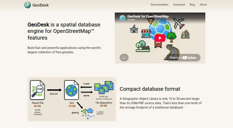
GeoDesk is a spatial database engine for OpenStreetMap data, aimed at developers building applications and people doing geospatial analysis. It stores OSM features in single-file Geographic Object Libraries (GOLs), which retain geometries and concepts such as relations. GeoDesk says these files are typically about 40 percent larger than OSM-PBF data but occupy a small fraction of a traditional database’s footprint. Its GOQL query syntax uses feature types and tags, and the maker says common spatial queries are typically 50 times faster than SQL equivalents. GOLs can be turned into compressed tile repositories for downloading selected regions. Tooling is available for Java, Python and C++, along with a command-line utility. Python mapping can display queried features in a browser or save them as Leaflet-based HTML maps. The software is free and open-source, with Linux, macOS and Windows listed. GeoDesk also documents integrations with Java Topology Suite and Python Shapely for vector operations.
Who it suits
GeoDesk suits developers and analysts working with OpenStreetMap data who need spatial queries, regional data handling or vector operations. It offers libraries and tools for Java, Python and C++ users.
What it does well
- Free and open-source.
- Stores OSM features in single-file libraries.
- Supports Java, Python and C++ tooling.
- Can package selected regions as compressed tiles.
- Documents Shapely and Java Topology Suite integrations.
What to know first
- Python quickstart requires Python 3.7 or higher.
- Building C++ requires a C++20 compiler and CMake 3.14 or later.
- No 3D geometry support.
Plans
| Plan | Billed and limits | Price |
|---|---|---|
| GeoDesk | 100% free and open-source | Free |
As geodesk.com lists them, read 30 Sept 2026. The maker's own page has the final word.
Getting started
- Visit the GeoDesk website and choose the Java, Python or C++ tools, or the GOL command-line utility.
- Build a library from an OpenStreetMap PBF file with the GOL tool.
- Use GOQL to query features by type and tags.
- For Python, use Python 3.7 or higher; for the C++ library, use a C++20-capable compiler and CMake 3.14 or later.
- Optionally convert a GOL into a compressed tile repository or use Python mapping to display queried features.
GeoDesk is a free, open-source spatial database engine built around OpenStreetMap data. It is best for developers and analysts who need compact, self-hosted OSM storage and fast feature queries in Java, Python or C++. Choose it for OSM-specific performance and tooling; look elsewhere if you need 3D geometry or a general-purpose database platform.
Overview
GeoDesk stores OpenStreetMap features in single-file Geographic Object Libraries (GOLs), rather than in a conventional server database. The design keeps OSM concepts such as relations intact and targets applications, map products and analysis pipelines that work directly with OSM data. It is self-hosted, with no hosted service or subscription to manage.
The project comes from an independent team focused on cartography and geospatial work. GeoDesk states that it is not affiliated with, endorsed by or sponsored by OpenStreetMap, so users should treat it as an independent toolchain for OSM data.
Key features
The GOL command-line utility imports OpenStreetMap PBF files into the single-file format. GeoDesk says a GOL is typically about 40 percent larger than its PBF source, while remaining a small fraction of the footprint of a traditional database. That makes a library straightforward to move or archive, although it does not minimize storage as aggressively as the source PBF itself.
GeoDesk reports that its most common spatial queries run 50 times faster than equivalent SQL queries. The benefit is aimed at OSM-style feature and tag lookups, not every database workload. GOQL is a concise query language based on feature types and tags and resembles MapCSS, giving OSM users a focused alternative to SQL. A GOL can also become a compressed tile repository, so a downloader can retrieve only the regions required instead of a complete dataset.
For geometry processing, documented integrations connect Java Topology Suite and Python Shapely to operations such as buffers, unions and triangulation. GeoDesk’s Python Map feature renders queried features in a Leaflet-based map that can open in a browser or be saved as HTML. Coordinate transforms are supported. The spatial type set covers points, lines, rings, polygons, multi-geometries and geometry collections, but not 3D geometry.
Developer tooling and guides cover Java, Python and C++, alongside the GOL utility. Python requires version 3.7 or newer. GeoDesk says it performs well on systems capable of running 64-bit Java or Python, while the C++ toolkit documentation covers 64-bit Windows, Linux and macOS. Building that C++ library requires a C++20-capable compiler and CMake 3.14 or later, a meaningful setup constraint for older build environments. Documentation, tutorials, GitHub repositories and API references provide the main support path.
Pricing
GeoDesk costs nothing. The GeoDesk plan is 100% free and open-source, with self-hosted deployment. There is no free trial because the product is already offered as a free plan, and no seat, usage or renewal charge is stated. This suits individuals, research projects and teams that can run and maintain their own tools; it does not provide a paid hosted tier for readers who want managed operations.
Platforms
GeoDesk supports Linux, macOS and Windows. The documented C++ toolkit specifically lists 64-bit versions of all three. Java and Python tooling broadens the practical choice of development environment, subject to the Python 3.7-or-newer requirement and the need for 64-bit Java or Python-capable hardware.
Who it's for
Choose GeoDesk for software that builds on OpenStreetMap’s feature model, repeated spatial lookups, regional data distribution or geospatial analysis. It is particularly compelling when a portable file and OSM-aware relations matter more than SQL compatibility. Analysts can combine GOQL with Shapely or Java Topology Suite, and developers can publish browser-viewable Leaflet maps from Python.
It is a poor fit for systems that require 3D geometry, a general relational database, or a managed cloud service. Teams standardizing on SQL will also need to learn GOQL and adapt workflows around GOL files.
Pros and cons
- Pro: Single-file GOLs preserve OSM relations and remain far smaller than a traditional database, simplifying distribution and local deployment.
- Pro: GeoDesk reports up to 50-times-faster common spatial queries than SQL equivalents for workloads matching its feature-and-tag model.
- Pro: Java, Python and C++ libraries, a command-line importer and documented geometry integrations support several development stacks.
- Pro: Compressed tile repositories allow regional downloads instead of requiring an entire dataset.
- Con: GOLs are usually about 40 percent larger than the originating PBF files, so they are not the smallest possible OSM representation.
- Con: The engine has no 3D geometry support and its OSM-focused query model is not a drop-in replacement for SQL.
- Con: C++ users need a C++20 compiler and CMake 3.14 or newer, which can complicate older build systems.
Alternatives
Spatial Databases is the broader category to survey when you want to compare engines beyond GeoDesk’s OSM specialization.
Azure SQL Database is a better choice when you need a cloud SQL service, broad platform access and a free offer with 100,000 vCore seconds, 32 GB of data storage and 32 GB of backup storage across up to 10 databases per subscription.
CrateDB fits teams wanting a distributed database with a free shared tier of 2 vCPUs, 2 GiB RAM and 8 GiB storage rather than a local OSM file engine.
MySQL is the conventional choice for SQL and NoSQL applications, replication and high-availability components through its Community Edition.
RavenDB suits users seeking a document database with developer and community deployment options.
Supabase is preferable when a hosted development platform and services such as database, authentication-oriented usage and file storage are more important than OSM-native storage.
DuckDB UI offers a browser-based local SQL notebook with optional MotherDuck connectivity for readers who want an interactive SQL interface.
Microsoft SQL Server is the established SQL Server route for teams that need its enterprise or standard editions.
OpenSearch is a free Apache 2.0 option when open-source search and analytics are the priority.
Verdict
GeoDesk is a strong recommendation for developers and analysts building OSM-centric applications that benefit from portable files, OSM relations and fast spatial lookups. Its free, open-source self-hosted model removes licensing cost and its multi-language tooling is practical. Pick another database when you need 3D data, SQL-first interoperability or managed hosting.
Verdict
GeoDesk provides OSM-focused storage, query and developer tools across several languages. Its C++ build has specific compiler and CMake requirements, and it does not support 3D geometry.
Questions
How much does GeoDesk cost?
GeoDesk is free and open-source.
Which platforms does GeoDesk support?
The listed platforms are Linux, macOS and Windows. The C++ toolkit documentation specifies 64-bit support for those systems.
Which programming languages can I use with GeoDesk?
GeoDesk provides tooling and developer guides for Java, Python and C++, as well as a GOL command-line utility.
Does GeoDesk support 3D geometry?
No. The listed geometry support does not include 3D geometry.
Can GeoDesk integrate with geometry libraries?
GeoDesk documents integrations with Java Topology Suite and Python Shapely for vector operations, including buffers, unions and triangulation.
Who makes GeoDesk?
GeoDesk describes its maker as an independent team of developers interested in cartography and geospatial topics.
Facts from GeoDesk's own pages
- Affiliation
- GeoDesk says it is not affiliated with, endorsed by, or sponsored by OpenStreetMap. · geodesk.com, 30 Sept 2026
- Audience
- GeoDesk describes its intended use as building fast applications and performing geospatial analysis with OpenStreetMap data. · geodesk.com, 30 Sept 2026
- Build requirements
- Building the C++ library requires a C++20-capable compiler and CMake 3.14 or later. · docs.geodesk.com, 30 Sept 2026
- Data format
- GeoDesk stores OSM data in single-file Geographic Object Libraries (GOLs). · docs.geodesk.com, 30 Sept 2026
- Data import
- The GOL tool builds libraries from OpenStreetMap PBF files. · docs.geodesk.com, 30 Sept 2026
- Developer libraries
- GeoDesk provides Python, Java and C++ options alongside its command-line GOL tool. · geodesk.com, 30 Sept 2026
- Geometry integrations
- GeoDesk documents integration with Java Topology Suite and Python Shapely for vector operations including buffers, unions, and triangulation. · docs.geodesk.com, 30 Sept 2026
- Hardware
- GeoDesk says it performs well on systems that can run 64-bit Java or Python. · docs.geodesk.com, 30 Sept 2026
- Integrations
- GeoDesk documents integration with Java Topology Suite and Python Shapely for vector operations. · docs.geodesk.com, 30 Sept 2026
- Languages
- GeoDesk provides tooling and developer guides for Java, Python, and C++, plus a GOL command-line utility. · geodesk.com, 30 Sept 2026
- Maker
- GeoDesk describes its maker as an independent team of developers interested in cartography and geospatial topics. · geodesk.com, 30 Sept 2026
- Maker details
- The About page does not state the maker’s headquarters or founding year. · geodesk.com, 30 Sept 2026
- Mapping
- The Python Map feature creates Leaflet-based web maps that can be saved as HTML or shown in a browser. · docs.geodesk.com, 30 Sept 2026
- OSM model
- GOLs store geometries and support OpenStreetMap concepts such as relations. · docs.geodesk.com, 30 Sept 2026
- OSM support
- GOLs store shapes and support OpenStreetMap concepts including relations. · geodesk.com, 30 Sept 2026
- Platform support
- The C++ toolkit documentation lists 64-bit Windows, Linux and macOS support. · docs.geodesk.com, 30 Sept 2026
- Purpose
- GeoDesk is a spatial database engine for OpenStreetMap features. · geodesk.com, 30 Sept 2026
- Python requirement
- The Python quickstart says Python 3.7 or higher is required. · docs.geodesk.com, 30 Sept 2026
- Query language
- GeoDesk provides GOQL, a concise query syntax based on feature types and tags and similar to MapCSS. · docs.geodesk.com, 30 Sept 2026
- Query performance
- GeoDesk says its queries are typically 50 times faster than SQL queries. · geodesk.com, 30 Sept 2026
- Query speed
- The most common spatial queries perform fifty times faster than their SQL equivalents, according to GeoDesk. · docs.geodesk.com, 30 Sept 2026
- Regional data
- A GOL can be turned into a compressed tile repository so users can download only the regions they need. · docs.geodesk.com, 30 Sept 2026
- Storage
- Geographic Object Libraries are single files typically about 40 percent larger than OSM-PBF data and a small fraction of a traditional database’s footprint. · docs.geodesk.com, 30 Sept 2026
- Support
- The official site links to documentation, tutorials, GitHub repositories, and API references for its tools and language libraries. · geodesk.com, 30 Sept 2026
Where GeoDesk stands on Freedom251
- Spatial Databases#13 of 40