A hurricane can strengthen quickly when warm ocean water supplies heat and moisture, thunderstorms concentrate that energy near the storm’s center, and the storm’s circulation stays organized enough to build on itself. Deep ocean heat, atmospheric moisture, wind shear, and the storm’s size and alignment all affect how readily that process works. No single ingredient guarantees rapid intensification.
What rapid intensification means—and what drives it
Rapid intensification describes a hurricane gaining strength quickly. The phrase is useful for explaining a change in a storm, but it does not, by itself, specify a particular wind-speed increase or time interval. The NOAA sources cited here do not provide an operational numerical threshold, so it is more accurate to treat the term qualitatively than to attach an unverified cutoff to it.
As an Amazon Associate I earn from qualifying purchases.
The basic energy source is the ocean. A hurricane’s surface winds help transfer heat and moisture from warm water into the atmosphere. Water evaporates, adding vapor to the air near the surface. When moist air rises and cools, vapor condenses into cloud and rain, releasing latent heat. That heating supports more rising air and helps sustain the storm’s circulation. NOAA’s National Ocean Service explains this fuel pathway in its hurricane-formation overview.
Free tools Windows power users keep installed
One-click scans. No signup required.
This is a reinforcing process, not a simple one-way transfer. A stronger storm has stronger surface winds, which can increase the exchange of energy with the ocean. NOAA’s Atlantic Oceanographic and Meteorological Laboratory (AOML) describes this feedback as Wind-Induced Surface Heat Exchange, or WISHE: stronger winds can support greater energy transfer, which can in turn help a storm strengthen further. The exchange also depends on the moisture contrast between the ocean surface and the air above it; warmer ocean temperatures can increase that contrast. These processes help explain how strengthening can accelerate, but they do not make it inevitable. See AOML’s summary of the ocean-energy feedback research.
#1 Best Overall
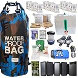
- Comprehensive Hurricane Kit: This pre-packed hurricane kit includes all the essential hurricane preparedness items for home safety, such as a hurricane lantern, hurricane food, and a hurricane radio weather radio, ensuring you are fully prepared for any emergency.
- Waterproof and Durable Bag: Conveniently packed in a waterproof bag, this hurricane emergency kit is designed to protect your hurricane supplies for home from water damage, ensuring that all your essential hurricane preparedness items remain dry and functional.
- Designed for Two People: Our hurricane kit emergency for home is thoughtfully designed to cater to the needs of two people, including enough hurricane preparedness items food, water and hurricane lights for indoor use, providing peace of mind for you and your loved ones.
- Essential Hurricane Gear: This kit includes a variety of essential hurricane items such as a led hurricane camping lantern, hurricane phone charger, and emergency hurricane supplies to ensure that you have all the necessary tools for effective hurricane preparedness.
- Emergency Communication Tools: Stay informed with the included hurricane radio weather radio, an indispensable part of your hurricane supplies. This radio ensures that you receive critical updates and alerts, making it a vital component of your hurricane emergency kit.
Why warm surface water is only part of the story
Sea-surface temperature matters because it affects the heat and moisture available at the air–sea boundary. NOAA gives water of at least 26.5°C extending through a depth of 50 meters as a rule-of-thumb ingredient in hurricane formation. That is a formation-oriented explanatory guide, not a universal guarantee of hurricane development and not a standalone threshold for rapid intensification.
The temperature at the surface does not reveal how much warm water lies beneath it. If a storm stirs the upper ocean, it can bring cooler water upward and reduce the heat available at the surface. Where warm water extends deeper, the storm may be less affected by that mixing. Ocean heat content and the path of currents and eddies can therefore matter alongside the surface temperature. They are part of the storm’s fuel supply, not a separate guarantee that the storm will strengthen.
Hurricane Michael in 2018 illustrates why looking at several conditions together is more informative than labeling the whole environment simply favorable or unfavorable. NOAA AOML reports that Michael experienced vertical wind shear earlier in its development and nevertheless underwent several stages of rapid intensification. Ocean observations along its track identified high sea-surface temperature and heat content in the Loop Current and associated eddies, among other features. This case shows that environmental factors can coexist and interact; it does not establish a template that every storm will follow. NOAA’s account is available in its analysis of ocean conditions during Michael’s intensification.
How wind shear can disrupt—or fail to stop—strengthening
Vertical wind shear is a change in wind speed or direction with height. If winds aloft push a hurricane’s clouds away from its low-level center, the storm’s thunderstorms and associated heating can become displaced from the circulation they would otherwise help strengthen. That separation generally makes intensification harder: heating far from the center is less effective at supporting a compact, organized storm core.
Rank #2

- 72-HOUR EMERGENCY KIT FOR 2: Built for disaster preparedness at home, work or on the road, this 2-person survival backpack includes food, water, first aid, lighting, hygiene and shelter essentials for up to 3 days.
- FOOD, WATER & PURIFICATION: Includes two 2,400-calorie emergency food bars, six 4.225 oz water pouches, water purification tablets and a 32 oz BPA-free bottle to help support hydration and nutrition during outages or evacuations.
- FIRST AID & PERSONAL PROTECTION: Packed with a 33-piece first aid kit, 2 N95 dust masks, nitrile gloves, hygiene kits, ponchos, survival blankets and tissues for added protection, sanitation and comfort during emergencies.
- POWER, LIGHTING & COMMUNICATION: Includes a hand-crank emergency power station with flashlight, AM/FM radio, siren and cell phone charging, plus 2 emergency lightsticks and a 3-in-1 whistle, compass and thermometer.
- DELUXE SURVIVAL TOOLS IN ONE BACKPACK: Adds a multi-function tool, duct tape, bio-hazard bag and emergency contact card in a portable backpack. Ideal for earthquakes, hurricanes, blackouts, wildfire evacuation, cars and workplaces.
But shear is not an on/off switch. How much disruption it causes depends partly on the storm’s structure and on the other conditions around it. A well-organized circulation can be more resistant to being disrupted, while storm-specific processes can sometimes sustain convection and vorticity production even when shear is high. Michael is one example of rapid intensification occurring after earlier exposure to shear; it should not be read as proof that shear is unimportant. The practical point is to assess shear in context rather than assume either that low shear guarantees strengthening or that higher shear rules it out.
Why the storm’s internal organization matters
Heat and moisture have to be converted into sustained, well-placed thunderstorms and circulation. If strong thunderstorms repeatedly form near the low-level center, their heating can support rising motion and help deepen the circulation. If the storm’s center, clouds, and heating are poorly organized or displaced, the same broad ocean conditions may not produce the same response.
AOML’s July 22, 2026 account of Hurricane Hunter radar research examines vertical alignment: how the storm’s lower and upper structures are positioned relative to each other and to environmental winds. The account identifies a strong, compact circulation near the surface, a favorable tilt relative to wind shear, upward motion and rain near the low-level center, warm water, and abundant moisture as features associated with alignment. These observations make alignment a potentially useful precursor to watch, not a promise that rapid intensification will follow. The AOML radar-research account describes the findings and their relevance to anticipating storm changes.
The Tool Desk
Outbyte PC Repair FREERepair Windows errors before they cause bigger problemsFix Now →Outbyte Driver Updater FREEScan for outdated or missing drivers - takes under a minuteDriver Scan →Compactness is relevant because a concentrated low-level circulation and nearby heating can form a more coherent system than a broad or poorly organized one. Alignment also matters because vertical separation can leave the storm’s center and its strongest thunderstorms working at cross-purposes. Neither characteristic should be used alone as a forecast: the storm still needs supportive ocean and atmospheric conditions, and its structure can change.
Rank #3

- [7400mWh (2000mAh) POWER BANK WILL KEEP DEVICES POWERED] The FosPower FOSPWB-2376 emergency radio incorporates a 7400mWh (2000mAh) power bank capable of providing emergency power to any small tablet or phone.
- [3 POWER SOURCES POWER WHEN YOU NEED IT] Use the emergency weather radio's 3 power sources when you need a boost of power or need to recharge the radio. The radio's crank lever and solar panel are both capable of regenerating enough power to keep the radio, lights, and SOS alarm ready to go when you need it most. AAA Batteries ensure you have power when not able to regenerate power.
- [2 LIGHT SOURCES ALWAYS POWERED] The emergency crank radio can also provide light. The 4 LED reading light and 1W flashlight provides enough output to keep you and your loved ones out of the dark in an emergency situation.
- [NOAA EMERGENCY WEATHER BROADCAST ACCESS] The radio will dependably receive up to the second emergency weather forecasts and emergency news broadcasts from NOAA and AM/FM stations.
- [LIMITED LIFETIME WARRANTY] Includes a Limited Lifetime Warranty. Please visit FosPower's website for more information.
How to compare the conditions without turning them into a formula
Rapid intensification is an interaction among the ocean, atmosphere, and storm structure. The following comparisons are useful for understanding what forecasters and researchers examine, but they are not a scoring system. A favorable value in one row cannot cancel every unfavorable factor in another.
| Factor | What to look at | Why it matters |
|---|---|---|
| Ocean warmth | Surface temperature and the depth of warm water; current features and eddies along the storm’s path | Surface warmth supports evaporation and heat transfer; deeper heat can help keep the storm supplied when the upper ocean is stirred. |
| Atmospheric moisture | Moisture available to the storm and the contrast between ocean and air | Moist air supports cloud and rain production, while the ocean–air moisture contrast affects transfer from the surface. |
| Wind shear | How wind changes with height and how it affects the storm’s clouds and circulation | Shear can displace thunderstorms and heating, but its influence depends on storm organization and other processes. |
| Storm structure | Compactness and strength of the low-level circulation; position of convection and heating relative to the center; vertical alignment | Organized, well-placed heating can support the circulation, while displacement or misalignment can impede it. |
| Location and timing | Whether the storm is over open water, near a current or eddy, or approaching a coast; when the conditions occur | Ocean features and coastal processes can change what heat and moisture are available, and conditions can vary along one storm’s track. |
A 2021 comparison of North Atlantic and eastern Pacific storms using records from 1982–2016 found that rapidly intensifying storms were associated with warmer sea-surface and upper-air temperatures, greater ocean heat content, greater upper-level divergence, and weaker vertical wind shear than slowly intensifying storms. The repository summary also reports basin differences in humidity and other variables. These are observed associations across the storms and period studied, not evidence that one variable alone caused rapid intensification. The NOAA Central Library record describes the comparison.
Independent reader supportYour contribution helps us test, update, and keep practical guides available for everyone.Why coastal conditions can complicate the forecast
The ocean near a coast is not necessarily a fixed or uniform source of energy. AOML summarizes modeling research in which coastal downwelling—a change in ocean conditions near the coast—can increase heat and moisture transfer into the atmosphere ahead of a landfalling cyclone. In the modeled mechanism, that additional transfer creates conditions conducive to intensification even with strong vertical wind shear.
Do these 3 things before closing this tab:
1Clear out junk files and repair common Windows errors2Fix the driver behind crashes, sound loss and screen glitches3Repair Windows errors before they cause bigger problemsThe work uses Hurricane Sally and a high-resolution hurricane model. It is evidence for a mechanism with forecasting relevance, not a general rule that landfalling storms intensify or that coastal water overrides shear. Nearshore conditions vary, and the modeled result should be interpreted in the scope of the case and research described. AOML provides the details in its summary of coastal ocean-temperature changes and intensification.
Rank #4

- Removes Bacteria & Parasites: The Microfiltration Membrane Removes 99.999999% of Waterborne Bacteria (Including E. Coli and Salmonella), and 99.999% of Waterborne Parasites (Including Giardia and Cryptosporidium) - Essential for Your Survival Kit
- Removes Microplastics: Removes the Smallest Microplastics Found in the Environment (Down to 1 Micron), and Reduces Turbidity Down to 0.2 Microns - Ideal for Hiking and Camping Essentials
- Rigorous Testing: All Claims Are Verified with Laboratories Using Standard Testing Protocols Set by the US EPA, NSF, ASTM for Water Purifiers
- Long Lifetime: The Microbiological Purification System Will Provide 4,000 Liters (1,000 Gallons) of Clean and Safe Drinking Water - a Must-Have for Your Bug Out Bag
- Make an Impact: For Every LifeStraw Product Purchased, a School Child in Need Receives Safe Drinking Water for an Entire School Year. Essential Camping Accessory Made With BPA Free Materials
What the Atlantic Coast trend does—and does not—show
A 2022 NOAA AOML summary reports an average increase of about 1.3 miles per hour in hurricane intensification rate near the U.S. Atlantic coast over the study period. For the same period, the study did not find a significant increase near the Gulf Coast. The result is geographically specific: it is not a global trend, does not describe every storm, and should not be used to predict the next hurricane’s change in wind speed.
The distinction matters because a regional average over a study period answers a different question from what will happen to one storm in one location. Individual hurricanes encounter different ocean features and atmospheric conditions, and their structure changes over time. The underlying paper is Balaguru et al. (2022), “Increasing hurricane intensification rate near the US Atlantic coast,” in Geophysical Research Letters, 49, e2022GL099793. NOAA AOML summarizes the finding on its Atlantic Coast hurricanes page.
How to interpret a forecast of quick strengthening
When a storm is forecast to intensify, the useful question is not simply whether the water is warm or the shear is low. The more complete picture asks whether the ocean can continue supplying heat and moisture, whether the atmosphere can support organized thunderstorms, and whether those thunderstorms are positioned to reinforce the storm’s center.
Recommended Free Tools
- Read ocean conditions in depth. Surface temperature is informative, but heat content and currents or eddies can affect how persistent the energy supply is.
- Consider the atmosphere and ocean together. Moisture and the surface moisture contrast help explain energy transfer; wind shear can interfere with the placement of convection.
- Watch the storm’s structure. Compactness, vertical alignment, and rain or rising motion near the low-level center can indicate a more organized configuration, but they are not guarantees.
- Keep location and time attached to any statistic or case. Michael, Sally, the Atlantic Coast trend, and the 1982–2016 basin comparison each describe different evidence and cannot be generalized into one rule.
That combination is why a storm can strengthen very quickly when several supportive processes line up—and why even apparently favorable conditions do not ensure that it will. Rapid intensification is not the result of warm water alone, low shear alone, or a single radar signature. It emerges when the ocean’s energy supply, atmospheric conditions, and the hurricane’s internal organization reinforce one another.
Quick Recap
Product prices and availability are accurate as of the date/time indicated and are subject to change. Any price and availability information displayed on Amazon at the time of purchase will apply.




