Windows Errors? Fix Them Before They Spread
Repair common Windows errors and clear accumulated junk for a smoother, more stable PC - no reinstall needed.Free scan · no reinstallCrashes, No Sound, or Screen Glitches?
Random freezes, missing sound and display glitches usually trace back to one bad driver. Find and replace yours safely.Free scan · under a minuteA high-altitude weather balloon is the lift system, not the measuring device. A small instrument package called a radiosonde rises through the atmosphere, samples temperature, pressure and relative humidity, and radios its readings to a ground station. GPS tracking records the package’s changing position, allowing the station to calculate wind speed and direction at different heights. The processed vertical profile, called a sounding, feeds forecasts, numerical weather models and atmospheric research.
The balloon carries the instrument; the radiosonde makes the measurements
The essential distinction is easy to miss: the balloon provides buoyancy, while the radiosonde collects atmospheric observations. NOAA’s National Weather Service describes a radiosonde as a small, expendable instrument package suspended below a weather balloon. The package contains sensors, a battery, a radio transmitter and position-tracking equipment. The balloon simply lifts that package through air that would otherwise be difficult to sample continuously from the ground.
As an Amazon Associate I earn from qualifying purchases.
A typical radiosonde weighs 60–80 grams, according to the National Weather Service radiosonde fact sheet. It hangs 25–35 meters (about 80–115 feet) below the balloon. That separation helps keep heat released by the balloon from contaminating the temperature sensor’s measurements. The exact hardware and suspension arrangement can differ between observing networks.
As the package ascends, it measures conditions at successive heights and transmits the observations to a receiving station. The station combines the measurements with GPS position and timing, performs quality checks, and produces a vertical atmospheric profile. Meteorologists call that profile a sounding.
#1 Best Overall

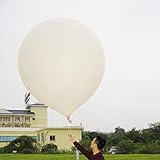
- Huge balloon,100g,about 6ft/72 inch after inflation,Lift off altitude about 26000m
- natural color close to white , can be painted the color you want, easy to track or entertainment
- Ideal for fairs aerial photos,meteorologists, science projects and grand openings.
- 72‘’ balloon Approximately 100 grams of items can be lifted (not accurate calculation, only approximate value, you need to measure it after you buy the balloon)
- These balloons must be filled with helium if they want to float up. You need to buy helium locally or fill it with hydrogen in a laboratory to ensure safety (dangerous, not recommended for ordinary people).
How the data-collection chain works
1. The station prepares and suspends the radiosonde
Before launch, technicians activate the radiosonde’s battery, check the sensors and radio link, and attach the package below the balloon. The package is deliberately expendable: it is designed to provide a reliable ascent profile rather than to return for routine reuse.
The long tether reduces thermal interference from the balloon. It also keeps the instrument in relatively undisturbed air below the balloon’s wake. The balloon is filled with hydrogen or helium, gases lighter than the surrounding atmosphere that provide lift.
2. The balloon rises as surrounding pressure falls
Near the ground, the balloon has a defined volume and lift. With increasing altitude, atmospheric pressure decreases, so the gas inside expands. The balloon grows larger as it climbs until its elastic material reaches its limit and ruptures. The ascent rate depends on balloon size, payload mass, gas fill and atmospheric conditions.
Recommended Free Tools
The National Weather Service gives an ascent rate of about 300 meters per minute (approximately 1,000 feet per minute) as typical. A typical flight can exceed 35 kilometers (about 115,000 feet) and last more than two hours, although the actual height, route and duration vary by launch system and weather. NOAA’s Atlantic Oceanographic and Meteorological Laboratory likewise says flights can exceed two hours and rise above 115,000 feet in its explainer, “Upper Air Observations: How Weather Balloons Improve Forecasts”, published September 1, 2017 and updated June 7, 2024.
3. Sensors sample the air every second
The radiosonde’s core sensors measure three properties directly:
| Measured property | What it tells forecasters |
|---|---|
| Temperature | How warm or cold the air is at each level, revealing lapse rates, inversions and the structure of weather systems. |
| Pressure | The force exerted by the air above the instrument; pressure decreases with altitude and provides a vertical reference. |
| Relative humidity | How close the air is to saturation at its current temperature, helping identify cloud-forming layers and moisture transport. |
GPS supplies the package’s position and time. The National Weather Service says pressure, temperature, relative humidity and GPS position data are transmitted each second. NOAA’s National Centers for Environmental Information describes upper-air products that include temperature, humidity, wind speed and direction, atmospheric pressure and geopotential height. Those products are available through its Weather Balloon service.
Rank #2
- 2 PCS Hwoyee professional huge balloon,For meteorological purposes, the Suggested Inflation Volume of a 50g balloon is 0.11-0.15m ³, Net Lifting Force=150g, Total Lifting Force=450g, Bursting Altitude=12000 m/49000 feet.
- Natural color close to white ,Neck Length≥6cm,Neck Diameter≤3.9cm,Body Length=45-55cm.
- Ideal for fairs aerial photos,meteorologists, science projects and grand openings.
- If you are using it for other purposes, you can charge more helium or hydrogen gas to achieve greater lift near the ground.
- If need to fly,these balloons must be filled with helium if they want to float up. You need to buy helium locally or fill it with hydrogen in a laboratory to ensure safety (dangerous, not recommended for ordinary people).
Sampling every second does not mean that every reported level is exactly one second or one fixed distance apart. The balloon is moving vertically and horizontally, and the processing system assigns observations to pressure or height levels suitable for analysis and model input.
Quick wins for a faster PC:
Scan for outdated or missing drivers - takes under a minuteDriver Scan →Clear out junk files and repair common Windows errorsFree Scan →Fix the driver behind crashes, sound loss and screen glitchesFind Drivers →4. A radio link carries observations to the ground
A battery-powered transmitter sends each measurement to a ground receiver while the radiosonde remains within reception range. The National Weather Service fact sheet states a typical radio-frequency range of 400–405.9 MHz for the system it describes. That range is a fact-sheet specification, not a universal frequency for every radiosonde or national network.
The receiving station decodes the signal, associates the data with the correct launch, and combines the stream with tracking information. If the radio link is interrupted, the station may lose part of the profile; quality-control systems flag gaps or values that fail physical and consistency checks.
5. GPS tracking turns motion into wind
The radiosonde does not usually carry a propeller or anemometer to measure wind directly. Instead, it is carried horizontally by the air. GPS reports how its latitude, longitude and altitude change with time. The processing system calculates displacement between successive positions, yielding wind speed and direction at successive levels.
NOAA distinguishes a basic radiosonde observation from the wind information obtained when the instrument is tracked. Technically, an observation that includes these derived winds is a rawinsonde observation, although “radiosonde” is commonly used for the entire package and sounding. Wind estimates become less reliable when position fixes are noisy, data are missing or the balloon’s motion is affected by unusual flight behavior.
What’s actually slowing this PC down?
Pick the symptom - the matching free tool is one click away.
6. The station builds and checks a sounding
Raw sensor readings are converted into meteorological units and paired with height or pressure. Automated software checks for impossible values, abrupt jumps, timing errors and inconsistent relationships between variables. National centers can apply additional quality control before archiving and distributing the profile.
Rank #3
- Hwoyee professional huge balloon,For meteorological purposes, the Suggested Inflation Volume of a 300g balloon is1.5-1.8m ³, Net Lifting Force=810g, Total Lifting Force=1360g, Bursting Altitude=18000m.
- Natural color close to white ,Neck Length≥10cm,Neck Diameter≤6.4cm,Body Length=135-160cm.
- If you are using it for other purposes, you can charge more helium or hydrogen gas to achieve greater lift near the ground.
- If need to fly,these balloons must be filled with helium if they want to float up. You need to buy helium locally or fill it with hydrogen in a laboratory to ensure safety (dangerous, not recommended for ordinary people).
- Ideal for fairs aerial photos,meteorologists, science projects and grand openings.
The final sounding is a vertical record rather than a single weather value. It can show, for example, a moist layer near the surface, a dry layer above it, a temperature inversion, or a change in wind direction with height. Forecasters can compare the latest sounding with earlier launches and with model analyses.
What a sounding contains
A sounding’s most familiar plots place temperature and dew point against pressure or altitude. From the same observation stream, systems can provide:
- Temperature and humidity at successive pressure or height levels.
- Atmospheric pressure and geopotential height, which link pressure surfaces to physical altitude.
- Wind speed and direction derived from tracked horizontal movement.
- Quality flags, observation times and the location of the launch and each reported level.
Because the radiosonde samples air directly along its path, it can reveal sharp vertical changes that would be smoothed or missed by measurements taken only at the surface.
Free tools Windows power users keep installed
One-click scans. No signup required.
How high, how fast and how long?
The following figures are typical values stated by the National Weather Service fact sheet, not guarantees for every flight:
| Flight detail | Typical stated value | Why it matters |
|---|---|---|
| Radiosonde mass | 60–80 grams | Payload mass affects the balloon’s lift and ascent rate. |
| Separation below balloon | 25–35 meters (80–115 feet) | Reduces heat-related contamination of temperature readings. |
| Ascent rate | About 300 meters per minute (1,000 feet per minute) | Determines how quickly the profile moves through each atmospheric layer. |
| Maximum altitude | More than 35 km (about 115,000 feet) | Reaches the lower stratosphere on a typical high-altitude flight. |
| Flight duration | More than two hours | Allows observations across a deep column of the atmosphere. |
| Radio frequency | 400–405.9 MHz | Frequency range stated by that NWS fact sheet; other systems may differ. |
| Transmission cadence | Every second | Provides a dense time series during ascent. |
Actual performance changes with launch-site elevation, balloon type, gas fill, payload configuration, winds, temperature and the altitude at which the balloon bursts.
What happens when the balloon bursts?
At high altitude, the balloon’s expanding gas stretches the envelope until it ruptures. The radiosonde then descends, normally under a small parachute or a slowing device, while the balloon material falls separately. The instrument continues transmitting for some portion of the descent if power and the radio link remain available, but the primary operational objective is the ascent profile.
Rank #4
- Hwoyee professional huge balloon,For meteorological purposes, the Suggested Inflation Volume of a 200g balloon is 1.0-1.2m ³, Net Lifting Force=760g, Total Lifting Force=1210g, Bursting Altitude=17000 m.
- Natural color close to white ,Neck Length≥10cm,Neck Diameter≤6.4cm,Body Length=90-104cm.
- If you are using it for other purposes, you can charge more helium or hydrogen gas to achieve greater lift near the ground.
- If need to fly,these balloons must be filled with helium if they want to float up. You need to buy helium locally or fill it with hydrogen in a laboratory to ensure safety (dangerous, not recommended for ordinary people).
- Ideal for fairs aerial photos,meteorologists, science projects and grand openings.
Most radiosondes are not recovered and returned to service. Their expendable design keeps the package light and simplifies global observing operations. The descent path can carry the package far from the launch site, so recovery is uncertain. Local aviation, land-access and environmental rules govern where launches may occur and how equipment is handled after landing.
Why forecasters need these measurements
Weather models require a three-dimensional description of the atmosphere. Surface stations describe conditions at the ground, but they cannot by themselves show how temperature, moisture and wind change through the troposphere and lower stratosphere. Soundings provide observations at many levels that can be assimilated into numerical weather prediction systems.
Forecasters use the profiles to assess stability, freezing levels, cloud and precipitation potential, jet-stream structure, turbulence risk and the depth of moisture or dry air. Researchers use archived profiles to study atmospheric processes and to evaluate satellite retrievals and model performance. NOAA NCEI maintains upper-air products for these applications.
At a launch station, meteorologists can compare the observed profile with a model forecast. A mismatch may reveal that a frontal boundary is arriving early, that a low-level inversion is stronger than expected, or that moisture is concentrated in a different layer. Those corrections can improve short-term forecasts and help model systems start from more accurate initial conditions.
Independent reader supportYour contribution helps us test, update, and keep practical guides available for everyone.In-situ balloon measurements versus satellite remote sensing
A radiosonde makes an in-situ measurement: its sensors are physically inside the air being sampled. NOAA/AOML explains that satellites estimate atmospheric variables from remotely observed radiation using radiative-transfer equations, whereas balloon observations provide direct measurements.
| Characteristic | Radiosonde sounding | Satellite remote sensing |
|---|---|---|
| Measurement method | Sensor samples the air directly along the ascent path. | Instrument observes radiation and retrieves atmospheric properties indirectly. |
| Vertical detail | Fine-scale profile at the launch location and along the flight path. | Broad geographic coverage; vertical detail depends on instrument and retrieval method. |
| Coverage pattern | Discrete launches at equipped stations. | Large-area or global observation from orbit. |
| Strength | Direct, high-resolution reference measurements for temperature, moisture and winds. | Consistent coverage over oceans and remote regions where launches are sparse. |
| Limitation | Limited to the balloon’s moving path and launch schedule. | Values depend on retrieval algorithms and can be affected by clouds or surface conditions. |
These systems complement rather than replace one another. Balloon soundings provide vertical truth at specific locations; satellites supply spatial context and frequent views across areas without ground stations.
Best Value

- Teach kids Bernoullis Principle and Pascals Principle using this solar balloon
- Large balloon impresses kids
- Balloon measures 50 feet long x 29 inches diameter
Why implementations differ between stations
“A weather balloon measurement” is not one immutable hardware design. Sensor packages, tracking methods, launch procedures, telemetry frequencies and processing software vary by network and location. The National Weather Service Charleston operational description, for example, identifies temperature and humidity components while noting that software derives pressure and wind. That illustrates why a reader should not assume every station uses identical sensors or reports variables in exactly the same way.
The common architecture remains stable: a buoyant balloon lifts an expendable package, the package samples atmospheric properties, radio telemetry sends the data to the ground, and tracking supplies the motion needed to derive winds. The details determine resolution, reliability and which additional products a station can provide.
Can a consumer weather-balloon kit reproduce an operational sounding?
An educational balloon project may demonstrate the basic idea of lifting sensors into the air, but the official sources do not establish that a retail “weather balloon kit” can reproduce National Weather Service observations. Operational soundings require calibrated sensors, reliable telemetry, position tracking, quality control, airspace coordination and procedures appropriate to the launch location.
The Tool Desk
Outbyte Driver Updater FREEScan for outdated or missing drivers - takes under a minuteDriver Scan →Outbyte PC Repair FREERepair Windows errors before they cause bigger problemsFix Now →Anyone considering a launch must address aviation restrictions, radio regulations, helium or hydrogen handling, recovery of falling equipment and environmental responsibilities. A classroom demonstration should be treated as an educational experiment, not as a substitute for an official upper-air observation.
Reading the result: from measurements to a vertical profile
The finished sounding is best understood as a stack of observations ordered by pressure or altitude. Temperature and humidity traces show where air is saturated or stable; wind barbs or vectors show how flow changes with height; pressure and geopotential height connect the thermodynamic and wind information to the atmosphere’s vertical coordinate.
Because the balloon drifts while it rises, the profile is not a perfectly vertical sample at one geographic point. It is a time-ordered path through the air. Processing software records the changing position so users can interpret each measurement at the correct location and level.
The result is more informative than a single maximum altitude figure. It reveals the structure of the atmosphere that controls clouds, storms, visibility, turbulence and the movement of weather systems—exactly the information needed to initialize and evaluate forecast models.
Do these 3 things before closing this tab:
1Scan for outdated or missing drivers - takes under a minute2Repair Windows errors before they cause bigger problems3Fix the driver behind crashes, sound loss and screen glitchesQuick Recap
Product prices and availability are accurate as of the date/time indicated and are subject to change. Any price and availability information displayed on Amazon at the time of purchase will apply.




