An unmanned mine-countermeasures (MCM) mission needs a complete system of systems, not simply an autonomous boat or underwater drone. The usual equipment set combines a launch and recovery platform, unmanned surface or underwater vehicles, mine-detection sensors, mission-specific payloads for identification or neutralization, navigation and communications, command-and-control software, data-processing tools, and trained operators and maintainers. The exact mix depends on the mine type, water depth, operating area, required standoff distance, and whether the mission is hunting mines or sweeping an area.
What an unmanned MCM mission must accomplish
Mine countermeasures covers several different jobs that are often grouped together but require different equipment. A force may need to detect a mine, classify the contact, identify it, neutralize it, or clear a route by sweeping for mines that respond to magnetic, acoustic, or other influences. One vehicle and one sensor rarely perform every task effectively.
As an Amazon Associate I earn from qualifying purchases.
- Detection: Find objects or mine-like signatures in the seabed, water column, or near-surface zone.
- Classification: Decide whether a detected object has characteristics consistent with a mine.
- Identification: Gather enough information to determine what the object is and how it should be handled.
- Neutralization: Use a dedicated system to defeat a mine at its location.
- Influence minesweeping: Generate the magnetic or acoustic influence that causes an influence mine to react, clearing a wider area without locating every mine individually.
Unmanned systems provide standoff: the crewed ship, boat, or aircraft can remain outside the immediate mine-threat area while the remote vehicle or payload works ahead of it. The architecture documented by the U.S. Navy for Littoral Combat Ship (LCS) operations illustrates this principle, but it is a U.S. Navy example rather than a universal equipment list.
Quick wins for a faster PC:
Repair Windows errors before they cause bigger problemsFix Now →Fix the driver behind crashes, sound loss and screen glitchesFind Drivers →Clear out junk files and repair common Windows errorsFree Scan →Core equipment categories
| Mission function | Equipment category | Documented example |
|---|---|---|
| Deployment and recovery | Host ship, vessel of opportunity, shore site, or small boat with handling gear | LCS launching an MCM unmanned surface vehicle (USV); Mk 18 UUVs deployed from Navy RHIB boats |
| Vehicle | Unmanned surface vehicle or unmanned underwater vehicle | MCM USV; Mk 18 Mod 1 Swordfish UUV |
| Minehunting | Towed or vehicle-mounted sonar | AN/AQS-20 sonar towed by the MCM USV |
| Near-surface detection | Airborne mine-detection sensor and helicopter | AN/AES-1 Airborne Laser Mine Detection System on an MH-60S |
| Neutralization | Airborne or underwater mine-neutralization payload | AN/ASQ-235 Airborne Mine Neutralization System on an MH-60S |
| Influence sweeping | Magnetic and acoustic sweep payload | Unmanned Influence Sweep System (UISS) carried by the MCM USV |
| Command and control | Vehicle-control, mission-management, communications, and decision-support software | LCS mission-package computing environment and multi-vehicle communications system |
| Analysis | Post-mission analysis, data fusion, and operator workstations | Mission-package analysis tools; expeditionary UUV post-mission-analysis and data-fusion cells |
The table separates functions because a sonar, a sweep generator, and a neutralization system do different work. Treating them as interchangeable leads to an incomplete mission design.
#1 Best Overall

- 4K 60FPS High Frame-rate Camera: Create epic footage and wonderful underwater moments with V-EVO's upgraded camera system, achieving professional-class shots with ease and enhanced smoothness.
- Removal SD Card: The new version is a removable SD card, providing you with more convenient gameplay and storage functions. The FIFISH V-EVO's hydrodynamic, fluid, and rugged water droplet design ensures minimal resistance against ocean currents, allowing for longer dives. An attachment port accommodates a variety of tools, enabling integration and versatility for various tasks and scenarios
- 360° Omnidirectional Mobility: Reach beyond the limits of traditional methods, and achieve full 360° freedom in underwater mobility, hovering and posture holds. Turn your creative imagination into cinematic 4K imaging reality.
- 5000 Ultra-bright Lumen LEDs: FIFISH V-EVO comes equipped with a pair of combined 5000 lumens · 5500K white LED lights. Optimize your vision across the deep sea and restore the colors of the world below, especially through dark and turbid environment.
- 166° Ultra Wide Lens: See the bigger picture and discover an extraordinary world below. Go beyond a conventional underwater lens to achieve a greater impact with your visuals.
Deployment, launch, and recovery equipment
Host platforms
An MCM USV can be launched from an LCS, another suitable vessel, or a shore location. The host supplies fuel or electrical support as applicable, communications beyond the vehicle’s local link, navigation references, handling equipment, and a protected place for operators and maintainers. An expeditionary UUV unit can operate from rigid-hull inflatable boats (RHIBs), which carry the vehicles and the equipment needed to put them into and recover them from the water.
Handling and support hardware
Launch and recovery is a mission-critical part of the equipment set. Planners need vehicle cradles or davits, lifting points, charging or fueling arrangements, transport cases, spare components, and a way to move the system between the host platform and a maintenance area. The 2016 Navy description of a Mk 18 platoon explicitly includes support equipment, small boats, and an air-mobile shelter. Those items show that an expeditionary package is a deployable unit, not just a collection of vehicles.
Standoff and operating area
The host platform should be able to remain outside the suspected minefield while maintaining reliable control and data paths. A shore-launched vehicle may offer geographic flexibility but requires a suitable beach, pier, or support site. A ship-launched system can relocate with the fleet but must fit the ship’s deck, handling, storage, and aviation arrangements.
Detection and localization sensors
Minehunting sonar
The LCS MCM architecture uses the MCM USV to tow the AN/AQS-20 minehunting sonar. A towed sonar places the sensor away from the vehicle’s own acoustic and mechanical noise and can be operated at a useful depth behind the USV. The vehicle must therefore provide controlled speed, precise navigation, tow-cable management, and enough endurance to survey assigned lanes.
Side-scan sonar and UUV surveys
The Mk 18 Mod 1 Swordfish UUV example uses dual side-scan sonar frequencies. Its sensors are described as collecting current speed, temperature, salinity, bathymetry, and depth. These environmental measurements help place sonar returns in context and support accurate mapping of the surveyed area. A UUV survey package also needs navigation sensors and a method for storing and transferring the large data sets produced during an autonomous run.
Near-surface mine detection
Not every mine sits on or near the seabed. The Navy’s LCS package assigns near-surface detection to an MH-60S helicopter equipped with the AN/AES-1 Airborne Laser Mine Detection System. This is a separate aviation module because an airborne sensor can search the upper water column and near-surface zone from a different geometry than a submerged sonar.
Navigation and environmental awareness
All detection systems require accurate position, depth, heading, and time references. A UUV also needs a navigation solution that remains useful when it is underwater and cannot continuously receive satellite positioning. Environmental sensors such as those listed for Swordfish provide water-column information that can affect sonar performance and help analysts interpret contacts. The exact navigation suite varies by vehicle and is not specified in the cited Navy descriptions.
Do these 3 things before closing this tab:
1Scan for outdated or missing drivers - takes under a minute2Repair Windows errors before they cause bigger problems3Fix the driver behind crashes, sound loss and screen glitchesRank #2

- 【More clearer And More Stable】GLADIUS MINI S captures epic moments with 4K HD video and 12 MP photos. It also comes with a 1/2.3 SONY CMOS, anti-video-shake feature, so you can record the beauty of the mysterious underwater world with more stable and vivid UHD video. With the combination of F2.8 lens and 2 x 1200 lumens LED lights, GLADIUS MINI S underwater drone can capture underwater details even in low light
- 【Up to 4 Hours of Flight Time】Equipped with two 4800 mAh batteries, GLADIUS MINI S underwater drone only takes 3.5H to fully charge the drone, It can reach up to 4 hours of flight time, This will also work for long hours of construction inspections and underwater exploration; In addition, the main unit is equipped with a 64GB SD card, but the GLADIUS MINIS underwater drone can support up to 512GB SD card, making it more convenient for downloading data, while also storing more photos and videos
- 【Move freely in the water】The GLADIUS MINI S underwater drone with camera is equipped with 5 thrusters, a maximum speed of 4 knots; with a maximum depth of 330 ft and a maximum horizontal shooting radius of up to 330 ft; The mini S underwater drone also adopts patented motor technology to prevent rolling in pebbles and sand; It works perfectly and reliably even in complex underwater environments with all patterns to meet your photography, Observing, and work needs at any angle you want
- 【Compatible with Sophisticated Attachments】GLADIUS MINI S underwater drone weighs only 6 lbs. which allow single-person operation and Quick- Deployment within 3 minutes; It supports a variety of mounts such as grabber claw, GoPro camera, etc.; GLADIUS MINI S is an underwater drone that meets the needs of various applications such as underwater photography, scientific exploration, and safety inspection, etc. Ideal for light industrial applications for a wide variety of professionals
- 【Stable Connection Remote Control】Underwater Camera Equip with wired connection remote controller to make the drone able to work stably and continuously without signal disconnections; Depth, temperature, and other parameters can be recorded at the same time; The App also supports live broadcasting or social media sharing, the ability to take photos while recording video, time-lapse photography, as well as quick editing features and HDMI output to other monitors or devices as well as save it on a removable SD card
Identification, classification, and neutralization payloads
Why detection is not neutralization
A sonar contact is an observation, not proof that a mine is present. Classification and identification require additional analysis and, where authorized, a closer look or another sensor. Neutralization then requires a payload designed for the mine’s location and type. A vehicle configured only with a survey sonar may find contacts but cannot necessarily defeat them.
Airborne neutralization
The LCS package pairs the MH-60S helicopter with the AN/ASQ-235 Airborne Mine Neutralization System. The Navy describes that system as countering moored, volume, and bottom mines. The documented sources establish the system-level capability; they do not provide operational employment instructions, firing procedures, or safety distances. Those details belong in controlled tactics and technical manuals rather than a general equipment list.
Modular payload bays
The MCM USV is listed at 38.5 feet long and has a modular payload bay. Modularity allows the same vehicle to tow a minehunting sonar on one sortie and carry a minesweeping payload on another, subject to the vehicle’s approved configuration and handling limits. It does not mean every payload can be swapped at sea or that one configuration has the same endurance, speed, or data requirements as another.
Influence minesweeping equipment
Influence sweeping attacks a different problem from image-based minehunting. The Unmanned Influence Sweep System combines the MCM USV with a sweep payload carrying a magnetic sweep cable and a towed acoustic generator. Those components create the influences intended to trigger mines that respond to magnetic or acoustic signatures. The Navy announced UISS initial operational capability in 2022.
A sweep system still needs navigation, lane planning, speed control, communications, and post-run assessment. Clearing a lane is not demonstrated merely by running a generator; the force must know where the system operated and how the cleared area relates to the threat and the next mission phase. A sweep payload therefore belongs in an integrated architecture with survey and analysis tools.
Command, control, communications, and data processing
Vehicle control
Operators need a control station that can plan routes, monitor vehicle health, send mission updates, and recover the vehicle if its autonomy or communications degrade. The LCS mission package includes vehicle-management software and a multi-vehicle communications system, allowing a host platform to coordinate more than one unmanned asset.
Mission management
Mission-specific software turns a search plan into vehicle behaviors: survey lanes, speed limits, turns, depth or altitude constraints, lost-link responses, and return-to-recovery rules. The LCS package also includes a mission-package computing environment and mine-warfare decision aids. These tools help operators combine sensor reports with chart data and previously collected information, but they do not remove the need for trained human judgment.
Rank #3
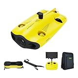
- 【4K UHD + EIS Camera】The gladius MINI S underwater drone provides 4K and 1080P videos and 12 megapixel photos to easily capture underwater details and take you to explore the mysterious underwater world. Meanwhile, the drone is equipped with 1/2.3 SONY CMOS and EIS function, F2.8 large aperture and 2 x 1200 lumen LED light, providing you with smooth and stable underwater photography.
- 【Dive to 330ft, Adjustable Attitude】The Chasing drone diving depth can reach 330ft, and the maximum horizontal shooting radius can reach 660ft, which can fully meet your shooting needs. Taking you to enjoy the breathtaking underwater scenery.
- 【Support Multiple Mounts】The gladius MINI S Underwater drone supports the attachment of mechanical arms and motion cameras. You can easily pick up objects in the water or shoot videos with higher pixel requirements. Aluminum alloy compact body (weight less than 6.6 pounds), The MINI S suit is equipped with mechanical arm, and our waterproof backpack, you can easily carry and use it more conveniently.
- 【Excellent Performance, Stable Connection】Chasing gladius MINI S underwater drone UAV CHASING anti-stuck patented motor technology, which can operate safely in complex underwater environments. Through the professional remote control, it supports WiFi and data cable to connect to the mobile phone / tablet computer. The wired transmission signal is more stable, does not occupy the mobile phone network, and is no longer disconnected.
- 【ATTENTION! Powerful Advantage Upgrade!】The gladius MINI S has Built in two 4800 mAh lithium batteries, the battery life is increased from the traditional 2 hours to 4 hours! The host is equipped with a 64GB SD card, unlike the traditional embedded memory card, the MINI S SD card is removable, It’s more convenient to extract pictures and videos, and also support up to 512GB SD card.
Data handling and analysis
Sonar and environmental sensors produce data that must be recorded, time-stamped, georeferenced, reviewed, and retained. The LCS architecture includes post-mission analysis tools. The expeditionary UUV example includes post-mission-analysis and data-fusion cells. A practical package therefore needs storage, analyst workstations, software for contact review, secure data transfer, and procedures for updating the operational picture after each run.
The Tool Desk
Outbyte Driver Updater FREEScan for outdated or missing drivers - takes under a minuteDriver Scan →Outbyte PC Repair FREERepair Windows errors before they cause bigger problemsFix Now →Communications constraints
An unmanned surface vehicle can usually maintain a radio or line-of-sight link more readily than a submerged UUV. An underwater vehicle may communicate only intermittently or after surfacing, depending on its design. The mission plan must account for that difference: autonomy, onboard logging, navigation updates, and recovery procedures become more important when continuous control is impossible.
People, maintenance, and sustainment
Unmanned does not mean unattended. Operators plan and supervise the mission, maintain the vehicles and payloads, inspect cables and connectors, manage batteries or fuel, and validate the data. The 2016 Navy fact sheet describes each of four UUV platoons as having 10 sailors and deploying with two to five UUVs, support equipment, small boats, and an air-mobile shelter. That is a dated architecture description from the 2016 Unmanned Warrior context, not a 2026 readiness count.
Planning should also provide:
- Qualified vehicle, sonar, aviation, and mission-system operators.
- Technicians for vehicle, payload, power, communications, and launch-and-recovery maintenance.
- Spare parts, batteries or fuel, calibration equipment, connectors, tow hardware, and protective cases.
- Transport and storage for vehicles and payloads between operating sites.
- Secure communications and data-management procedures.
- Safety, mine-threat, weather, and environmental procedures approved for the operating force.
- A post-mission team able to review contacts and feed results into the next search plan.
Exact staffing and logistics are system-specific. The categories above are planning implications, not a quoted universal Navy table of allowances.
A documented architecture: the U.S. Navy LCS MCM package
The Navy describes the LCS Mine Countermeasures Mission Package as an integrated suite of unmanned maritime systems and sensors intended to counter mines in littoral waters while increasing the host vessel’s standoff distance. Its published modules are:
| Module | Vehicle or platform | Primary equipment | Role |
|---|---|---|---|
| Remote Minehunting | MCM USV | AN/AQS-20 sonar | Minehunting from a towed sonar sensor |
| Near Surface Detection | MH-60S helicopter | AN/AES-1 | Detection and classification of near-surface moored mines |
| Airborne Mine Neutralization | MH-60S helicopter | AN/ASQ-235 | Countering moored, volume, and bottom mines |
| Unmanned Minesweeping | MCM USV | UISS payload | Magnetic and acoustic influence sweeping |
| Mission support | Host ship and mission systems | Mission software, multi-vehicle communications, shipboard computing, and analysis tools | Control, coordination, processing, and decision support |
The Navy declared initial operational capability for the MCM Mission Package and AN/AQS-20 sonar in March 2023. In a fact-file update dated July 2, 2025, it reported four packages embarked and supporting LCS deployments in the Fifth Fleet area, with follow-on packages intended to support Seventh Fleet operations by the end of fiscal year 2027. Those figures describe a dated program status and should be rechecked if a current fleet count matters. The same fact file says the Navy planned to procure 24 MCM mission packages.
Independent reader supportYour contribution helps us test, update, and keep practical guides available for everyone.A different architecture: expeditionary Mk 18 UUV operations
The Mk 18 Mod 1 Swordfish example is organized around expeditionary UUV platoons rather than an LCS mission package. Navy material from 2016 describes four platoons, each with 10 sailors and two to five UUVs, deploying from RHIB boats with support equipment and an air-mobile shelter. Swordfish uses dual-frequency side-scan sonar and environmental sensors for current speed, temperature, salinity, bathymetry, and depth. Post-mission-analysis and data-fusion cells turn the collected survey data into an operational picture.
Rank #4

- 【Excellent Underwater Photography】DORY can dive up to 49ft and has an HD camera for real-time observation and shooting photos and videos; DORY's 1080p F1.6 camera combined with two 250-lumen headlights opens up a whole new world of exploration; With DORY'S built in true color restoration algorithm, photos and videos show true dynamic color in all conditions
- 【Portable for Travel】As the world's smallest, smartest and most affordable underwater drone, palm sized DORY is just 9"7x7"4x3"6, weighs less than 2.5lbs; It has a 4800 mAh battery life of approximately 1 hour; Travelers can take it into a backpack and easily transport it wherever they want to use it
- 【Explore the Sea Like a game】DORY is really easy to use; Plug, dive and play; With the CHASING GO2 app, your phone can remotely control the underwater drone to dive, forward and backward, move up and down, tilt up and down and lock the depth like a gamepad; Exploring the ocean floor is as easy and fun as a game
- 【Share the fun】With Dory's dual play mode, you can operate the underwater drone with camera together with your close friend or family; What's more, with CHASING GO2 app, it's quick and easy to share live-streaming and underwater videos on Facebook, Instagram, Youtube, or your favorite social sharing platform; Shine at your next pool party or snorkeling adventures
- 【Freedom to explore deep sea】DORY connects to a small floating WiFi Buoy with a 49' tether and streams live 720p video from beneath the surface to your device and to social media if you like; Whether you're diving, fishing, taking underwater photography, or yachting, the Chasing DORY is your best choice
This architecture can be moved and staged differently from a ship-centered USV-and-helicopter package. It is not an interchangeable bill of equipment: the launch boats, shelter, staffing, navigation assumptions, communications pattern, and survey workflow all differ. The 2016 description should be read as an architecture example from that period, not evidence of the Navy’s current force size or readiness.
How to choose equipment for a mission
Start with the threat and task, not with a preferred vehicle. A useful configuration sequence is:
- Define the mine problem. Establish whether the suspected threat is moored, bottom, volume, or influence-activated, and whether it is expected near the seabed, in the water column, or near the surface.
- Choose the task. Decide whether the immediate requirement is detection, classification, identification, neutralization, influence sweeping, or a staged combination.
- Select the launch platform. Match the vehicle to the host ship, RHIB, shore site, or vessel of opportunity, including deck space, lifting equipment, storage, and recovery limits.
- Match sensors and payloads. Select towed or vehicle-mounted sonar, side-scan frequencies, airborne detection, neutralization equipment, or magnetic and acoustic sweep generators as the task requires.
- Design navigation and communications. Set the required positioning accuracy, lost-link behavior, underwater update method, control range, and data-transfer plan.
- Plan analysis. Provide onboard recording and a post-mission process for reviewing contacts, fusing data, and updating the next search plan.
- Staff and sustain the package. Assign trained operators, maintainers, analysts, transport, spares, power or fuel, and launch-and-recovery support before deployment.
Compare candidate architectures on mine type and water-column location; task; launch platform and standoff; sensor and payload coverage; mission duration and survey area; communications and analysis; and total support footprint. The cited Navy descriptions establish these equipment functions, but they do not provide a head-to-head performance ranking.
Common planning mistakes
- Buying a vehicle without a mission payload: A bare USV or UUV cannot detect or defeat a mine without an appropriate sensor or effecter.
- Confusing minehunting with minesweeping: Sonar searches for contacts; an influence sweep generates signatures intended to trigger responsive mines.
- Ignoring near-surface threats: A seabed survey does not substitute for an airborne or other sensor designed for moored mines near the surface.
- Underestimating data work: High-resolution sonar requires storage, transfer, analyst time, and georeferenced records.
- Treating autonomy as a replacement for supervision: Lost links, navigation errors, weather, fouling, and payload faults require human monitoring and recovery procedures.
- Using consumer equipment as a substitute: Generic recreational sonar or hobby UUVs do not establish the detection, classification, safety, communications, or neutralization capability required for a military MCM mission.
- Assuming a dated program number is current: The 2016 UUV platoon description and the July 2025 LCS fact-file figures are time-stamped program information, not timeless inventory counts.
What the equipment list cannot answer by itself
Equipment names do not reveal a mission’s probability of detection, clearance rate, endurance, weather limits, or safety procedures. Those outcomes depend on mine design, seabed conditions, clutter, water clarity, survey geometry, operator training, rules of engagement, and the approved tactics for the system. Public Navy descriptions identify the architecture and roles; they do not provide operational employment instructions or a universal performance comparison.
Frequently Asked Questions
Can one unmanned vehicle perform the entire MCM mission?
A modular vehicle may carry different payloads on separate sorties, but the documented Navy architectures divide minehunting, near-surface detection, neutralization, and influence sweeping among different sensors, aircraft, and payloads.
What is the difference between minehunting and minesweeping equipment?
Minehunting equipment, such as a towed or side-scan sonar, searches for and maps mine-like contacts. Minesweeping equipment creates magnetic or acoustic influences intended to trigger responsive mines over a lane or area.
Free tools Windows power users keep installed
One-click scans. No signup required.
Is the Mk 18 platoon size a current Navy inventory figure?
No. The description of four platoons, 10 sailors per platoon, and two to five UUVs dates from a 2016 fact sheet and is an architecture example, not a 2026 readiness count.
Why are communications and analysis part of the equipment answer?
Unmanned vehicles need control, health monitoring, navigation updates, data storage, and post-mission contact review. Without those functions, a sensor sortie does not produce a usable, georeferenced clearance picture.
Are consumer sonar systems suitable for a military mine-countermeasures mission?
No reliable equivalence is established. Consumer or hobby equipment does not provide the integrated sensing, navigation, communications, safety controls, neutralization payloads, and trained support required for this mission.
Quick Recap
Product prices and availability are accurate as of the date/time indicated and are subject to change. Any price and availability information displayed on Amazon at the time of purchase will apply.

