Do these 3 things before closing this tab:
1Repair Windows errors before they cause bigger problems2Scan for outdated or missing drivers - takes under a minute3Clear out junk files and repair common Windows errorsEvacuation zones are local, not nationwide. Your county or city’s emergency-management office decides which addresses are in each zone, when zones are activated, which routes are assigned, and where shelters open. Use that local address lookup and current evacuation order as the authority for your home. National storm-surge maps explain the hazard but do not replace a local order.
Leave as soon as officials direct your zone to evacuate, with enough time to avoid worsening weather, traffic, flooded roads and blocked routes. A safe destination is usually a nearby friend or relative in a well-built home outside flood-prone areas, a low-rise inland hotel, or a public shelter designated by local officials—you generally do not need to drive hundreds of miles.
As an Amazon Associate I earn from qualifying purchases.
What a hurricane evacuation zone means
An evacuation zone is an operational area drawn by state, county or municipal emergency managers. Zones usually reflect exposure to storm surge and flooding, but the boundaries, names, colors and activation order differ from one jurisdiction to another. A red or “Zone A” label in one county does not have the same meaning as that label elsewhere.
Quick wins for a faster PC:
Clear out junk files and repair common Windows errorsFree Scan →Scan for outdated or missing drivers - takes under a minuteDriver Scan →Repair Windows errors before they cause bigger problemsFix Now →Emergency managers may also issue orders for areas outside mapped hurricane zones. Flood-prone neighborhoods, mobile-home communities and locations threatened by rivers, creeks, dams or mudslides can require evacuation even when the address is not in a coastal surge zone. NOAA specifically advises residents in flood-prone areas and people living in mobile homes to be prepared to leave under those circumstances.
#1 Best Overall

- [7400mWh (2000mAh) POWER BANK WILL KEEP DEVICES POWERED] The FosPower FOSPWB-2376 emergency radio incorporates a 7400mWh (2000mAh) power bank capable of providing emergency power to any small tablet or phone.
- [3 POWER SOURCES POWER WHEN YOU NEED IT] Use the emergency weather radio's 3 power sources when you need a boost of power or need to recharge the radio. The radio's crank lever and solar panel are both capable of regenerating enough power to keep the radio, lights, and SOS alarm ready to go when you need it most. AAA Batteries ensure you have power when not able to regenerate power.
- [2 LIGHT SOURCES ALWAYS POWERED] The emergency crank radio can also provide light. The 4 LED reading light and 1W flashlight provides enough output to keep you and your loved ones out of the dark in an emergency situation.
- [NOAA EMERGENCY WEATHER BROADCAST ACCESS] The radio will dependably receive up to the second emergency weather forecasts and emergency news broadcasts from NOAA and AM/FM stations.
- [LIMITED LIFETIME WARRANTY] Includes a Limited Lifetime Warranty. Please visit FosPower's website for more information.
The National Hurricane Center’s National Storm Surge Risk Maps show modeled coastal hazard. Version 4 reprocessed Gulf and East Coast data with the latest SLOSH grids in 2025. Those maps are useful for understanding exposure, but a local emergency-management order determines what you should do at a particular address.
How to find your zone before a storm
- Open your local emergency-management website. Search for the county or city’s official “evacuation zone lookup” or “know your zone” page. Use the government source for the address where you live, work or regularly care for someone.
- Enter the complete address. Include the street number, street name, municipality and ZIP code. Check the returned parcel or map pin rather than relying on a nearby landmark.
- Record the zone and order sequence. Write down the zone name or letter, the official map date if shown, and which channels announce activations—such as emergency alerts, local government social accounts, radio or text notifications.
- Save an offline copy. Screenshot the lookup result and print the map or zone number. Power, cellular service and internet access can fail during a hurricane.
- Ask about special instructions. Contact the local office or emergency-information line if your property sits near a zone boundary, is in a mobile-home park, lies below a levee, or has residents who need transportation or medical assistance.
Do this before hurricane season. A forecast track can shift, and authorities can change the recommended route or expand an order as rainfall and flooding develop.
When should you leave?
When officials order your zone to evacuate
Leave immediately when local authorities issue an evacuation order for your zone or location. The National Weather Service’s plain-language instruction is: “Leave immediately if told to do so!” Do not wait for the storm to intensify or for conditions outside your window to look dangerous. Waiting compresses the time available for people with disabilities, families with young children and residents who need public transportation.
Use the hurricane warning as a deadline, not a starting signal
The National Weather Service defines a hurricane warning as hurricane conditions expected within 36 hours. When a warning is issued, preparations should be complete and anyone directed to evacuate should already be moving. Roads can become impassable before the eye arrives because of surge, freshwater flooding, fallen trees or accidents.
If no order has been issued
Monitor local emergency management, the National Weather Service and official emergency alerts. Do not self-evacuate into a more hazardous location without checking the destination. People in flood-prone areas, mobile homes or other vulnerable structures may need to leave based on local guidance even if a numbered zone has not been activated.
Rank #2
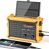
- 【Reliable 𝗡𝗢𝗔𝗔/𝗔𝗠/𝗙𝗠 Reception with Clear Sound】With a high-sensitivity signal chip, noise-reduction circuitry, and an extended antenna, the radio ensures 𝗳𝗮𝘀𝘁, 𝘀𝘁𝗮𝗯𝗹𝗲 𝗿𝗲𝗰𝗲𝗽𝘁𝗶𝗼𝗻 across NOAA FM AM bands. Whether you're sheltering during a storm or camping off the grid, you'll hear every update loud and clear.
- 【𝗛𝗶𝗴𝗵-𝗘𝗳𝗳𝗶𝗰𝗶𝗲𝗻𝗰𝘆 𝗦𝗼𝗹𝗮𝗿 𝗖𝗵𝗮𝗿𝗴𝗶𝗻𝗴 with Extra-Large Panel】The solar radio features a massive 8500mm² high-efficiency monocrystalline solar panel—over 4× larger than typical 2000mm² decorative polysilicon panels on the market. The expansive panel captures significantly more sunlight, delivering faster charging even in low-light conditions. Perfect for camping, power outages, and off-grid emergencies.
- 【𝗛𝗶𝗴𝗵-𝗧𝗼𝗿𝗾𝘂𝗲 𝗖𝗿𝗮𝗻𝗸 𝗣𝗼𝘄𝗲𝗿 for Fast Effortless Charging】With an upgraded internal generator—featuring a larger copper coil and reinforced magnet, the hand crank emergency radio delivers nearly 2× the charging efficiency of standard models. The extended crank arm offers smooth, low-effort rotation, letting you power up the radio or your phone in just 3 minutes when other sources fail. A must-have for your bug-out bag, survival kit, or emergency backpack.
- 【𝗧𝗿𝘂𝗲 𝟭𝟮𝟬𝟬𝟬𝗺𝗔𝗵 Power Capacity That Lasts】 Unlike inflated claims, the emergency crank radio is powered by a real 12000mAh lithium battery that keeps your gear running when you need it most. Whether you’re keeping the radio and lights on for days, you’ll have dependable energy throughout storms, blackouts, or outdoor adventures.
- 【Versatile Emergency Flashlight & Soft Reading Light】The noaa am fm radio includes a powerful flashlight that casts a focused beam up to 260 feet, perfect for dark trails, tents, or emergency navigation. Flip up the frosted reading lamp to enjoy a soft, warm glow that’s easy on the eyes. Both LED lights offer two brightness levels to match your needs—whether for safety or comfort.
Do you have to evacuate if you are not in a zone?
Not necessarily—but being outside a mapped zone is not a guarantee of safety. Zone maps commonly emphasize coastal storm surge; they may not cover every river, creek, dam-break, rainfall or mudslide threat. Local officials can issue an evacuation order for a specific neighborhood, building type or hazard area without using the standard zone sequence.
Residents should follow the order that applies to their address, not a color remembered from another county or a national map. If officials tell you to leave, comply even when your property appears outside the highlighted zone.
Free tools Windows power users keep installed
One-click scans. No signup required.
Where to go after an evacuation order
Choose the nearest safe destination
NOAA says you do not need to travel hundreds of miles. A friend or relative in a well-built home outside flood-prone areas is often the simplest option. Other possibilities include a low-rise inland hotel or a public shelter designated by local officials.
Screen a private destination for more than coastal surge. Check its risk from river or creek flooding, rainfall accumulation, dam-related flooding and mudslides. A place that is inland can still be unsafe if it sits in a low valley, behind a failing drainage system or below a dam.
Confirm that a public shelter is open
Shelter addresses, opening times, capacity and transportation services can change during an event. Check the current notice from your county or city before traveling. Do not assume a school, community center or shelter listed in an old preparedness brochure is operating for this storm.
Rank #3

- Massive 10000mAh Battery for Extended Emergency Power – Unlike standard models, this Emergency Weather Radio features a built-in 10000mAh rechargeable battery that provides backup power for your smartphone and essential devices during outages. The USB Output (5V/1A) supports emergency phone charging when grid power is unavailable. Ideal for hurricanes, winter storms, camping, RV travel, home emergencies, emergency kits, survival gear, and disaster supplies. Realistic Charging Expectations: The 10000mAh rating refers to the internal battery cell; actual output varies due to conversion loss and device efficiency. Expect approximately 1–1.5 charges for an iPhone 14.
- PX6 Waterproof & Compact Design – Ready for Outdoor Use – Rated IPX6 water resistant, this emergency radio is protected against water spray and splashing, making it suitable for camping, fishing, hiking, hurricane preparedness, and outdoor use. It is designed for splash resistance only and is not intended for heavy rain, immersion, or underwater use. Measuring approximately 6.3"L x 3.5"W x 3.1"H and weighing about 1.1 lbs (500g), this compact weather radio easily fits backpacks, go-bags, vehicles, RVs, and emergency storage areas without adding bulk. Includes a built-in compass for outdoor navigation support.
- 3-Mode Flashlight & Reading Lamp – Emergency Lighting Solution – This portable Emergency Radio includes a high-efficiency LED flashlight with three modes: High, Low, and SOS signaling for blackouts, nighttime emergencies, camping, and outdoor use. The built-in 1.3W reading lamp provides soft, wide-angle lighting for reading maps, checking emergency supplies, or navigating in the dark. Designed for camping gear, survival kits, hurricane preparedness, car emergency kits, and family emergency supplies, this weather radio provides dependable backup lighting when electricity is unavailable.
- NOAA Weather Radio & AM/FM – Manual Tuning, No Automatic Alert – Stay informed with NOAA weather broadcasts and AM/FM reception: AM 520–1710kHz, FM 87–108MHz, NOAA 162.400–162.550MHz. Manual Tuning Required: extend the antenna, select NOAA mode, then slowly rotate the tuning knob until the clearest local NOAA station is received. This NOAA Weather Radio does NOT support SAME technology, automatic NOAA alerts, or location-based alerts; users must manually tune to and listen to NOAA broadcasts. Large controls make tuning easier for families and seniors.
- 3 Charging Modes: Solar, Hand Crank & USB-C Input – Stay powered with USB-C Input, built-in solar panel, or hand crank generator when electricity is unavailable. About 1 minute of steady hand cranking provides 15–20 minutes of radio listening; actual runtime varies by use and cranking speed. The radio can be used while charging via USB-C, but charging may take longer. This Solar Radio and Hand Crank Radio supports hurricane supplies, camping essentials, outdoor adventures, RV trips, survival kits, and 72-hour emergency preparedness. Multiple charging methods keep your emergency radio ready for blackouts, storms, remote travel, and off-grid situations.
Do not return early
Wait for officials to announce that it is safe to return. Roads may be closed because of debris, downed power lines, structural damage or contaminated water. Never drive or walk through floodwater; even shallow moving water can sweep a person or vehicle away.
Plan routes and transportation
Choose several routes before hurricane season and identify at least one alternate for each direction. Local officials may assign routes by evacuation zone, convert lanes for outbound traffic or close roads as conditions change. A route that is best under a coastal-surge forecast may be unsuitable once inland flooding begins.
- Map the primary route. Note bridges, low-water crossings, tunnels and other points that could close.
- Map an alternate route. Keep it on a different road network where possible; two routes that share one bridge are not truly independent.
- Set a departure trigger. Leave when your zone is ordered, while roads remain passable, rather than waiting for congestion or rain to peak.
- Arrange transportation. Ask local emergency management about buses, paratransit, pickup points or medical transportation if you do not have a vehicle.
- Carry navigation offline. Keep a paper map and downloaded directions in case cellular service or power fails.
Monitor official instructions while traveling. A projected track, a new flood warning or a road closure can change the safest destination and route.
Shelters, pets and access needs
Pets
Most public shelters allow only service animals. Arrange a pet-friendly hotel, private home or designated animal shelter before the storm, and verify its current acceptance policy. Keep pets in carriers or on secure leashes and bring vaccination records, food, water, medications, bowls, waste bags and identification.
Medical and mobility needs
Put prescription medicines, mobility equipment, hearing or vision aids, backup batteries and medical documents in the evacuation bag. Tell emergency managers in advance if someone needs an accessible vehicle, electricity for medical equipment or a caregiver during transport.
Recommended Free Tools
Rank #4

- NOAA Weather Scan & Alert - This emergency weather alert radio features S.A.M.E localized programming and alert you to over 60 kinds of weather hazards and emergencies. NOAA Weather Scan will automatically alert you of events.
- S.A.M.E Localized Programming - The Specific Area Message Encoding (S.A.M.E.) allows the user to enter a code that is specific to your country, state, county and in some cases partial county.
- Notification Settings - Program your radio to receive weather alerts from up to 25 different counties and be alerted only when those specific counties are threatened. Color-coded alert indicators show the alert type and its severity.
- Additional Features - SAME localized programming, continuous backlighting option which keeps the LCD on, 25 programmable counties, color-coded alert indicators, alert override automatically switches to warn of impending danger.
- Experience a comprehensive range of radios from Midland, designed to keep you connected and informed. Our radios offer an array of features, including reliable real-time weather alerts, and robust two-way communication capabilities.
Infants and dependents
Pack formula, bottles, diapers, wipes and comfort items. Include communication cards or written instructions for anyone who cannot easily explain their needs during a hurried evacuation.
Independent reader supportYour contribution helps us test, update, and keep practical guides available for everyone.Build a three-day evacuation kit
Official preparedness guidance supports at least three days of food, water and medicine for each person. Store the kit where it can be loaded quickly and refresh medications, batteries and documents before every hurricane season.
- Water and ready-to-eat food for each person, including special diets
- Prescription and essential over-the-counter medicines
- Battery-powered NOAA Weather Radio
- LED flashlight or lantern and spare batteries
- Portable USB power bank, phone chargers and vehicle charging cables
- Identification, insurance information, property records and emergency contacts in a waterproof container
- Cash, hygiene supplies, first-aid items, sturdy shoes and a change of clothing
- Pet carrier, food, water, medicines, records and waste supplies
- Infant supplies and mobility or medical equipment
- Paper maps and a written list of routes and destinations
Keep fuel in the vehicle and do not rely on a single charging method. Gas stations, ATMs and stores may be closed or without power after an evacuation begins.
Hazards that make evacuation urgent
Storm surge is only one part of the threat. Hurricane rainfall along the Gulf and eastern United States accounts for about 10–15% of total annual rainfall, according to NOAA’s current safety guidance. That rain can produce inland flooding far from the coast and after the strongest winds have passed.
The Tool Desk
Outbyte PC Repair FREEClear out junk files and repair common Windows errorsFree Scan →Outbyte Driver Updater FREEScan for outdated or missing drivers - takes under a minuteDriver Scan →Six inches of moving water can knock an adult off their feet. More water can move a vehicle, hide washed-out pavement and expose occupants to electrical or chemical hazards. Turn around rather than entering a flooded road, and obey barricades even if the water looks shallow.
Best Value
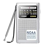
- Life Saver with NOAA Weather Radio:With crystal clear sound and our upgraded DSP chip, this weather radio can professionally receive the best weather broadcasts from seven NOAA radio stations, let you get notified first for every severe weather warning in your area, such as tornadoes, hurricanes and strongly storms.At any critical moment,let you be fully prepared in advance and use this AM FM radio to protect you and your family.Put this portable radio in your home and you always feel safe
- Best Reception with Easy To Use:With high sensitivity and selectivity, this weather radio has a thirteen-inch telescopic antenna that can capture excellent AM FM WB signal reception.Simple to use dial and switch knob allow you to easily listen to AM FM radio stations with one hand, so you won't be distracted from the beautiful scenery. Also this noaa radio is sturdy, compact and durable, you will get the authentic pleasure from this portable radio by taking it for a long trip or camping
- Super Long Lasting Time:This NOAA weather radio is powered by two AA batteries (not included) for two weeks of use and is easy to find in the supermarket or at home. Even if there is a hurricane outage, this weather radio will continue to receive the latest weather information for you to ensure the safety of you and your family. Therefore, just click the "Add to Cart" button to take this cost-effective AM FM radio home and be prepared for the storm
- Enjoy Personal Time:This weather radio has built-in small but high-performance speakers, you can feel the fun of the radio with beautiful sound fills your room. In addition, put this battery operated radio in your pocket, plug in headphones and see the scenery along the way, allowing you to enjoy your personal time in your busy life. And equipped with an intimate wristband, you can easily carry the emergency radio out for running or traveling. Small portable pocket size,carry it anywhere
- Ideal Gift and Worry Free:With its compact appearance and simple operation,our transistor radio is popular in many countries. If you are worrying about what to buy for your parents, grandparents or friends, this fm radio is your best choice. This weather radio is a carefully selected gift to prepare for the arrival of severe weather and protect their safety! And we guarantee a twelve-month manufacturer and 24/7 customer service to make it no risk for you to purchase this noaa radio
Wind can damage roofs, windows and power lines; surge can contaminate wells and septic systems; and mudslides can block roads on steep terrain. These hazards are why local orders can cover areas that are not colored on a coastal surge map.
How local evacuation systems differ
When you move, work across county lines or care for relatives in another state, compare the actual operating rules rather than the colors on a map.
| What to compare | Questions to answer |
|---|---|
| Address lookup | Does the official site locate a street address, parcel or manufactured-home community? |
| Zone definition | Is the zone based on storm surge, broader flooding, structure type or several hazards? |
| Order sequence | Which zones or populations are called first, and how much notice is normally provided? |
| Notice channels | Which alerts, phone systems, radio stations and official accounts announce changes? |
| Routes and transportation | Are evacuation corridors, buses, paratransit or pickup locations published? |
| Shelters and pets | Where are current shelters, and do they accept pets or only service animals? |
| Accessibility services | How do residents request accessible transport, power support or medical assistance? |
Colors and letters are not nationally standardized. Always use the current rules for the jurisdiction where the threatened address is located.
Windows Errors? Fix Them Before They Spread
Repair common Windows errors and clear accumulated junk for a smoother, more stable PC - no reinstall needed.Free scan · no reinstallOutdated Drivers Are Slowing You Down
One free scan finds every outdated or missing driver and matches the right update for your exact hardware.Free scan · exact hardware matchDuring and after the evacuation
- Keep phones charged and monitor official alerts, radio and local emergency-management updates.
- Stay out of closed areas and never bypass barricades.
- Conserve fuel and avoid unnecessary side trips that add traffic to evacuation corridors.
- Do not return until officials give an all-clear for your area.
- After returning, avoid downed lines, standing water, damaged structures and gas odors; report hazards through the local emergency system.
Write down your zone, two destinations, three routes, transportation contacts and the location of your evacuation kit now. That preparation turns a rapidly changing forecast into a clear decision when an order arrives.
Quick Recap
Product prices and availability are accurate as of the date/time indicated and are subject to change. Any price and availability information displayed on Amazon at the time of purchase will apply.

