Crashes, No Sound, or Screen Glitches?
Random freezes, missing sound and display glitches usually trace back to one bad driver. Find and replace yours safely.Free scan · under a minuteWindows Errors? Fix Them Before They Spread
Repair common Windows errors and clear accumulated junk for a smoother, more stable PC - no reinstall needed.Free scan · no reinstallYes—but only in a limited sense. Albedo Space’s Clarity-1 satellite was designed to capture visible imagery at a claimed 10-centimeter ground sample distance, enough to resolve a person as a small object from orbit. That does not mean it can automatically recognize faces, identify people by name, or continuously follow anyone.
The technology is real, but the most alarming headlines blur several different capabilities: detecting a person, classifying what they are doing, recognizing their appearance, identifying them, and tracking them over time. Those are not the same thing.
As an Amazon Associate I earn from qualifying purchases.
What satellite are we talking about?
The satellite is Clarity-1, built by U.S. aerospace company Albedo Space. It launched on March 14, 2025, aboard SpaceX’s Transporter-13 mission.
Free tools Windows power users keep installed
One-click scans. No signup required.
Clarity-1 was designed to operate in very low Earth orbit (VLEO), at an intended altitude of approximately 275 kilometers. Flying lower than conventional Earth-observation satellites allows a telescope to achieve finer ground resolution with a smaller or lighter optical system.
#1 Best Overall

- MEANT FOR ADVENTURE: Spot Gen4 provides critical, life-saving line of communication when you travel beyond cell towers; Let family know you're ok or push the SOS button to send your GPS to emergency responders if you need help
- NO CELL PHONE OR SERVICE-NO PROBLEM: With the Tracking feature Gen4 can transmit location updates when you are moving and when you stop; Keep one in your child's backpack for the walk home
- GLOBALSTAR SATELLITE & SPOT products use GPS to determine location and transmit GPS coordinates to others; SPOT users can notify friends, family or emergency rescue their exact GPS coordinates
- WHAT'S IN THE BOX: SPOT Gen4 device, Strap and Carabiner, USB Cable, Batteries and quick start guide; Subscription required; Two service plans available
- PURCHASE, ACTIVATE, EXPLORE: Grab a Spot Gen4; Activate by selecting your service plan; Get out there and explore the world with peace of mind
Albedo’s published specifications list:
- 10-centimeter native panchromatic ground sample distance at nadir;
- 12.4-centimeter resolution at 30 degrees off-nadir;
- 40-centimeter native multispectral resolution;
- approximately 2-meter long-wave-infrared resolution;
- a listed 15-day revisit rate for one satellite;
- about 1.5 revisits per day for a full planned constellation; and
- an advertised average delivery latency of 30 minutes.
These are company-published specifications, not a guarantee that every image will achieve those results. Cloud, haze, viewing angle, motion, lighting, focus, image processing, and collection priorities all affect the final product. Albedo’s specifications are available on its technical information page.
What does “10 centimeters per pixel” actually mean?
Ground sample distance, or GSD, describes the approximate ground area represented by one image pixel. At a 10-centimeter GSD, one pixel corresponds roughly to a 10-by-10-centimeter patch of ground under the stated imaging conditions.
In an idealized geometric example, a 1.8-meter-tall person would span roughly 18 pixels vertically. That is enough for the person to appear as a recognizable object rather than an indistinct dot. An image might reveal whether someone is standing, lying down, part of a group, or near a vehicle or building. Broad clothing colors and body position could also potentially be visible.
But “10 centimeters per pixel” is not the same as saying the image is sharp enough to read a face. Pixel size is a measurement of sampling, not a promise of photographic detail. Resolution generally becomes worse away from directly overhead, and atmospheric conditions or motion can remove information that the nominal specification suggests.
Can Clarity-1 see an individual person?
It can potentially resolve a person as an object in favorable conditions. That is the defensible meaning of the claim that the satellite can image individuals.
Open terrain, good lighting, limited haze, a near-nadir view, and a stationary subject would offer the best conditions. A person in vegetation, a crowd, deep shadow, a cluttered urban area, or a moving vehicle would be harder to distinguish.
The imagery could potentially show:
- the presence or absence of people;
- groups gathered at a location;
- approximate posture or movement;
- broad clothing or visual characteristics;
- activity around buildings, vehicles, or restricted sites; and
- changes at a location between image captures.
That is useful for mapping, disaster assessment, infrastructure monitoring, and intelligence. It is also why privacy concerns are reasonable. However, it is not evidence that Clarity-1 can identify every person it photographs.
What’s actually slowing this PC down?
Pick the symptom - the matching free tool is one click away.
Can it recognize faces or identify people by name?
That capability is not established by the 10-centimeter specification and would be unlikely from a single ordinary overhead image.
If a full body occupies roughly 18 pixels vertically in the idealized example above, the face occupies only a small fraction of that area. Recognition would also depend on the viewing angle, shadows, image quality, motion blur, hair, hats, masks, clothing, and whether the subject is looking upward.
Rank #2

- Premium GPS Tracker — The LandAirSea 54 GPS tracker provides accurate global location, real-time alerts, and geofencing. Easily attaches to vehicles, ATVs, golf carts, or other critical assets.
- Track Movements in Real-Time — Track and map (with Google Maps) in real-time on web-based software or our SilverCloud App. Location updates as fast as every 3 seconds with historical playback for up to 1 year.
- Powerful & Discreet — The motion-activated GPS tracker will sleep when not in motion for extended periods, preserving the battery life. The ultra-compact design and internal magnet create the ultimate discreet tracker.
- Lifetime Warranty — This GPS tracker is built to last. LandAirSea, a USA-based company and pioneer in GPS tracking offers a unconditional lifetime warranty that covers any manufacturing defects in the device encountered during normal use.
- Subscription Required — Affordable subscription plans are required for each device. Fees start as low as $9.95 a month for annual plans and $19.95 for monthly plans. No contracts, cancel anytime for a hassle-free experience.
Albedo has said its satellites would not be equipped with facial-recognition technology. That statement refers to an onboard capability; it does not prove that a customer could never apply external image-analysis software after receiving imagery. The distinction matters:
- Onboard facial recognition would mean the spacecraft itself analyzes faces.
- Post-processing would mean a customer, contractor, or government agency analyzes the delivered imagery with its own software.
The available evidence supports detection and broad classification in suitable conditions. It does not establish reliable biometric identification, name matching, or facial-expression analysis.
Can one satellite track a person continuously?
No—not in the movie-style sense of a camera remaining over one person. A satellite in low orbit moves rapidly across the Earth. It cannot hover above a house or follow an individual continuously.
Albedo lists a nominal 15-day revisit rate for an individual satellite. A future full constellation is listed at approximately 1.5 revisits per day, but that figure depends on the final number and placement of satellites, orbital geometry, tasking priorities, weather, and customer access.
Repeated tracking would require multiple successful collections and software capable of linking the same person, vehicle, or activity across images. In practice, it would generally be easier to associate a recurring vehicle, facility, or large activity pattern than to prove that the same specific person appears in every image.
Clouds are another major limitation. Visible imagery cannot see through clouds, and haze can degrade detail. The existence of a high-resolution sensor does not mean every requested location can be photographed whenever a customer wants.
Do these 3 things before closing this tab:
1Clear out junk files and repair common Windows errors2Scan for outdated or missing drivers - takes under a minute3Repair Windows errors before they cause bigger problemsWhy does flying lower improve resolution?
For a given telescope, reducing the distance between the sensor and the ground allows each pixel to cover a smaller area. Albedo says VLEO can provide roughly half the imaging distance of conventional low Earth orbit, improving the resolution of passive optical systems while also increasing signal levels and potentially reducing latency.
The trade-off is a much harsher operating environment. At roughly 275 kilometers, a spacecraft experiences significant atmospheric drag and atomic-oxygen exposure. It must manage orbital decay, propulsion, thermal conditions, communications, and attitude control more aggressively than a higher satellite.
That engineering difficulty is central to understanding both the promise and the limits of this technology. Higher resolution is not free: it is purchased with a more demanding orbit and potentially shorter or more complex mission operations.
Rank #3

- SATELLITE TRACKING DEVICE: Using satellite technology, Spot Trace can track anything, use it to track moving truck, boat use, even keeping an eye on loved ones or your car; Preprogram to send a status message at waypoints
- NO MORE LOST LUGGAGE: The Airline won't know where your luggage is-but you will; Also great for Kid's backpack to make sure their walk home was safe and even peace of mind when your teen borrows the car
- GLOBALSTAR SATELLITE & SPOT products use GPS to determine location and transmit GPS coordinates to others; SPOT users can notify friends, family or emergency rescue their exact GPS coordinates
- WHAT'S IN THE BOX: Spot Trace device, 4 AAA lithium 8X batteries, L92; 5V USB power cable and quick start guide; Subscription required; Two service plans available
- PURCHASE, ACTIVATE, EXPLORE: Grab a Spot Trace Sattellite Tracking Device; Activate by selecting your service plan; Get out there and explore the world with peace of mind
What happened to Clarity-1?
Clarity-1 should not be described as an uninterrupted operational spy platform.
Recommended Free Tools
In a January 2026 update, Albedo said the satellite had demonstrated most of the VLEO platform and validated 98% of the technology needed for its 10-centimeter imagery objective. But the company also said it lost contact with Clarity-1 approximately nine months into the mission, reportedly because of a suspected problem involving communications and onboard memory.
Albedo said the spacecraft remained in orbit and was maintaining attitude autonomously while descending through VLEO. Recovery attempts had not succeeded at the time of that update, and the company said the likelihood of recovery was low. The status update is available in Albedo’s account of what worked and what came next.
This failure does not erase the underlying capability. It does show that operating a high-resolution commercial spacecraft in VLEO remains technically difficult. The current reality is better described as a successful technology demonstration with a later communications failure—not a mature constellation watching people everywhere.
What is planned next?
Albedo has announced Vicinity, a second VLEO mission with a planned 2027 launch. The company says Vicinity will use design elements from the Precision bus used for Clarity-1 and support higher-power payloads, including imaging and defense-related missions.
Albedo’s longer-term plan involves producing additional spacecraft and deploying a constellation. The company’s public material suggests that imagery tasking was initially reserved for “Albedo Reserve” customers, with broader availability associated with future constellation deployment. It is not presented as an ordinary consumer satellite-camera service, and no public pricing is provided.
The announced plans are not the same as an operating constellation. They represent the company’s intended roadmap and remain subject to launch, spacecraft, regulatory, financing, and operational risks. Details about the next mission are available in Albedo’s Vicinity announcement.
Independent reader supportYour contribution helps us test, update, and keep practical guides available for everyone.Who would use this imagery?
The technology has applications well beyond surveillance of individuals. Potential uses include:
- mapping damage after fires, storms, earthquakes, or conflict;
- monitoring roads, pipelines, energy facilities, and other infrastructure;
- detecting thermal anomalies;
- supporting environmental and scientific observation;
- checking changes at industrial or maritime sites; and
- defense and intelligence collection.
Albedo identifies the National Reconnaissance Office, U.S. Space Force, Air Force Research Laboratory, and NASA’s Jet Propulsion Laboratory among organizations associated with the company. The NRO Stage II contract allowed government users to purchase and evaluate Albedo’s visible and thermal imagery from Clarity-1. The announcement mentions applications such as activity detection, indications and warnings, and target discrimination.
Rank #4
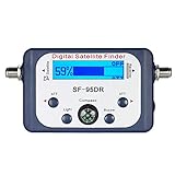
- High Quality Component: and professional design; Designed with a compass for easier and quicker tuning. Powered by the receiver, nice tool for campers.
- Less Signal Loss:Built-in amplifier compensates insertion loss.We offer one year warranty and 24 hours customers survice~
- Useful Tool|:Connect to your LNB and receiver to the satellite finder to track the clearest setting for the satellite you wish to tune to.
- Easy To Use:With electronic buzzer, easy operation, audio tone and LCD display with backlight to show the satellite signal intensity.
- No External Power or batteries required: power supplied from your satellite receiver.
A U.S. government SBIR award also describes work involving automated physical-damage detection using visible and thermal imagery. A related government portfolio description discusses proposed defense applications involving aircraft, vehicles, and their movements.
Where the privacy risk really lies
The strongest privacy concern is not necessarily that a satellite can read your face. It is the combination of high-resolution imagery with other systems.
Repeated images could be combined with vehicle databases, building records, mobile-location data, social-media posts, facial-recognition systems, gait analysis, clothing analysis, or government intelligence databases. A single image may only show an anonymous person. A large archive of images, linked to other information, can become much more revealing.
That risk could matter at protests, clinics, religious sites, border crossings, private homes, workplaces, and other sensitive locations. Automated systems may also search imagery at a scale that would be impractical for human analysts.
These are governance concerns, not proof that Clarity-1 has already been used to spy on civilians or identify people. The available public sources do not establish a complete privacy policy, retention schedule, customer-access regime, or universal legal framework for Albedo imagery.
What the satellite cannot automatically do
The available evidence does not establish that Clarity-1 can:
- read facial expressions from orbit;
- identify anyone by name;
- see through buildings;
- watch one individual continuously;
- see through clouds with its visible sensor;
- track every person on Earth;
- guarantee readable license plates; or
- determine a person’s intent from one image.
Even Albedo’s listed geolocation accuracy—approximately 5 meters CE90 for its stated nadir specification—shows why image resolution and geographic precision should not be confused. A picture can contain very fine visual detail while its placement on a map is not accurate to the size of a 10-centimeter pixel.
The unanswered policy questions
The technology raises questions that the public specifications do not answer:
Quick wins for a faster PC:
Repair Windows errors before they cause bigger problemsFix Now →Scan for outdated or missing drivers - takes under a minuteDriver Scan →Clear out junk files and repair common Windows errorsFree Scan →- Who can task the satellite and what review is required?
- Are individuals ever notified that they were imaged?
- How long are images and derived analytics retained?
- Can imagery be resold or shared with multiple customers?
- Are sensitive sites or vulnerable populations excluded from collection?
- Can customers combine the imagery with facial recognition or location databases?
- What oversight applies when commercial imagery is sold to government agencies?
Those questions become more important if Albedo or other providers successfully deploy constellations that increase revisit frequency. The privacy impact depends not only on the camera, but also on who can access the data, how often locations are revisited, what automated tools are applied, and what safeguards govern storage and sharing.
Bottom line
Albedo’s technology represents a meaningful step toward aircraft-like Earth-observation imagery from orbit. A 10-centimeter image can potentially show people as objects and reveal broad activity in favorable conditions. It does not automatically provide face recognition, identity, continuous tracking, or omniscient surveillance.
As of Albedo’s January 2026 update, Clarity-1 had validated most of the company’s VLEO technology but had later lost communications. A follow-up mission, Vicinity, was planned for 2027, while government contracts show that the capability has genuine national-security relevance. The immediate story is therefore not that a satellite can spy on everyone. It is that increasingly detailed commercial imagery is becoming technically feasible—and that privacy rules, access controls, and oversight may need to catch up.
Quick Recap
Product prices and availability are accurate as of the date/time indicated and are subject to change. Any price and availability information displayed on Amazon at the time of purchase will apply.
The Tool Desk
Outbyte PC Repair FREEClear out junk files and repair common Windows errorsFree Scan →Outbyte Driver Updater FREEFix the driver behind crashes, sound loss and screen glitchesFind Drivers →
