spopt
What spopt is
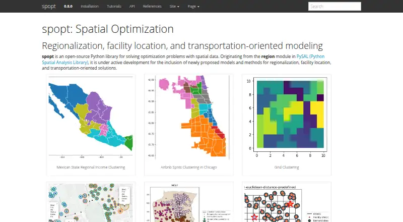
spopt is an open-source Python library for optimization tasks involving geographic data. Its methods cover regionalization, facility location, and transportation-oriented problems. For regionalization, it groups smaller geographic units into larger regions using approaches such as AZP, MaxP, Skater, and spatially constrained clustering. Facility-location models include set covering, maximal coverage, p-median, p-center, p-dispersion, and flow refueling location. Documented examples include clustering regional income, Airbnb, and grid data, along with choosing sites for first-aid stations and stores.
The library supports Linux, macOS, and Windows, and its installation guide calls for Python 3.11 or later. Install a released package through pip or conda-forge, or get a development version from GitHub. Requirements include SciPy, NumPy, pandas, NetworkX, libpysal, scikit-learn, GeoPandas, PuLP, Shapely, and spaghetti. A facility-location example uses PuLP with the CBC solver. The project is under active development and welcomes contributors. It is licensed under BSD 3-Clause and offered free.
Who it suits
spopt suits Python users working on spatial analysis, geographic clustering, regionalization, or facility siting. Its documented examples range from regional income and Airbnb clustering to locating first-aid stations and stores.
What it does well
- Covers regionalization, facility location, and transportation-oriented solutions.
- Includes AZP, MaxP, Skater, and spatially constrained clustering methods.
- Provides multiple facility-location models, including p-median and maximal coverage.
- Runs on Linux, macOS, and Windows.
- Released packages are available through pip and conda-forge.
- Free and licensed under BSD 3-Clause.
What to know first
- Requires Python 3.11 or later.
- Requires several scientific, geospatial, and optimization packages.
- A facility-location example uses PuLP with the CBC solver.
Plans
| Plan | Billed and limits | Price |
|---|---|---|
| spopt | Open-source Python library · BSD 3-Clause license | Free |
As pysal.org lists them, read 5 Oct 2026. The maker's own page has the final word.
Getting started
- Use a Linux, macOS, or Windows environment with Python 3.11 or later.
- Install a released package with pip or conda-forge.
- Install the development version from GitHub if you need that version.
- Review the documented examples for clustering or facility-location workflows.
- Ask questions through GitHub issues, GitHub discussions, or PySAL’s Discord channel.
Verdict
Choose spopt if your work involves Python-based spatial optimization, including geographic clustering or facility siting. Its wide range of regionalization and location models is the main reason to consider it. Account for the Python 3.11-or-later requirement and its listed package dependencies when choosing a setup.
Questions
How much does spopt cost?
The free plan costs nothing.
Which platforms does it support?
It supports Linux, macOS, and Windows.
What Python version does it require?
The installation guide says spopt supports Python 3.11 or later.
How can I install it?
Released packages can be installed with pip or conda-forge. A development version can be installed from GitHub.
Is spopt open source?
Yes. The repository states that it is licensed under BSD 3-Clause.
What kinds of problems can it solve?
Its methods cover regionalization, facility location, and transportation-oriented solutions, including clustering geographic units and locating facilities.
Facts from spopt's own pages
- Dependencies
- The repository lists SciPy, NumPy, pandas, NetworkX, libpysal, scikit-learn, GeoPandas, PuLP, Shapely, and spaghetti as requirements. · github.com, 5 Oct 2026
- Development
- The project says it is under active development and welcomes contributors. · github.com, 5 Oct 2026
- Examples
- Documented examples include regional income clustering, Airbnb clustering, grid clustering, and locating first-aid stations or store sites. · pysal.org, 5 Oct 2026
- Facility location
- Its facility-location methods include set covering, maximal coverage, p-median, p-center, p-dispersion, and flow refueling location models. · pysal.org, 5 Oct 2026
- Focus areas
- The project develops methods for regionalization, facility location, and transportation-oriented solutions. · pysal.org, 5 Oct 2026
- Install options
- The released package can be installed with pip or conda-forge, and a development version can be installed from GitHub. · pysal.org, 5 Oct 2026
- Intended audience
- The project describes itself as a spatial optimization package and provides examples involving geographic clustering and facility siting. · github.com, 5 Oct 2026
- License
- The repository states that spopt is licensed under the BSD 3-Clause license. · github.com, 5 Oct 2026
- Purpose
- spopt is an open-source Python library for solving optimization problems with spatial data. · pysal.org, 5 Oct 2026
- Python requirement
- The installation guide says spopt supports Python 3.11 or later. · pysal.org, 5 Oct 2026
- Regionalization
- Its regionalization methods aggregate smaller geographic units into larger regions using methods such as AZP, MaxP, Skater, and spatially constrained clustering. · pysal.org, 5 Oct 2026
- Security
- The repository identifies itself as a public project and links to its security and quality page, but the opened pages make no security or compliance claims. · github.com, 5 Oct 2026
- Solver example
- The repository’s facility-location example uses PuLP with the CBC solver. · github.com, 5 Oct 2026
- Support
- Users can ask questions through GitHub issues, GitHub discussions, or PySAL’s Discord channel. · pysal.org, 5 Oct 2026
Where spopt stands on Freedom251
- GIS Software#21 of 64