NetMap
What NetMap is
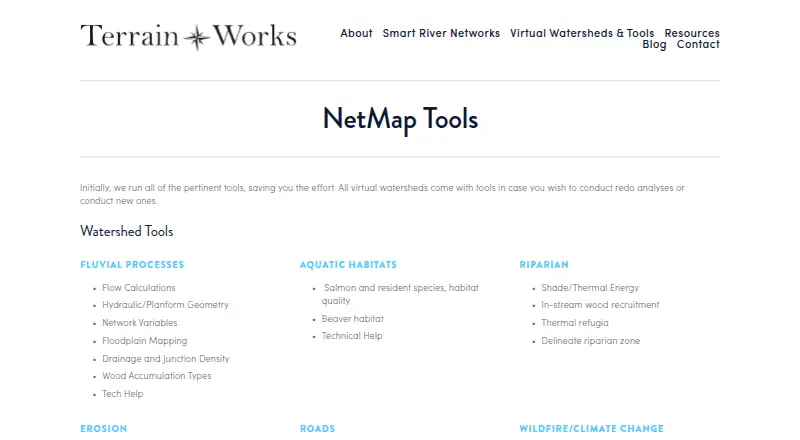
NetMap is TerrainWorks software for simulating watershed landforms, natural processes, and land-use interactions during planning and evaluation. Its tools address fluvial processes, aquatic habitats, riparian conditions, erosion, roads, wildfire, climate change, and watershed analysis. Virtual watershed datasets can include channel environments, floodplains, aquatic habitats, riparian attributes, erosion susceptibility, road attributes, and wildfire or climate data. Elevation inputs range from LiDAR to 10 m DEMs, with 5 m IfSAR or LiDAR in Alaska. The Virtual Watershed Portal lets users explore data online and search for fish habitat, floodplains, riparian zones, and landslide potential. Desktop geospatial tools are offered for ArcGIS Pro and ArcMap. Analysis includes watershed delineation, downstream aggregation, profile graphs, database queries, and Google Earth export. TerrainWorks also offers Smart River Networks as a free download. NetMap is paid with pricing on request; desktop use requires suitable hardware, proprietary software, and experience.
Who it suits
NetMap suits resource managers, restoration planners, hazard and wildfire assessors, conservation groups, and researchers needing watershed decision support. It is intended for users who can provide the required ArcGIS environment and technical experience.
What it does well
- Models landform and land-use interactions
- Covers wildfire, erosion, habitats, and climate
- Online watershed exploration portal
- ArcGIS Pro and ArcMap tools
- Includes multiple export and analysis functions
What to know first
- Pricing is available only on request
- Desktop use requires proprietary software
- Adequate hardware and experience are required
- NetMap provides no free plan
Plans
| Plan | Billed and limits | Price |
|---|---|---|
| NetMap User License | Annual; fee depends on number of users, number of datasets, geographic extent, and organization type; contact TerrainWorks for pricing. · Access to specified existing virtual watershed datasets and tools · license generally expires after 12 to 13 months unless renewed · datasets do not expire | On request |
| Builder / NetMap as a Service | Contact TerrainWorks for fee structure. · For new virtual watershed datasets or analyses performed by TerrainWorks · includes one year of tool support and maintenance · datasets do not expire | On request |
As terrainworks.com lists them, read 11 Oct 2026. The maker's own page has the final word.
Verdict
NetMap offers detailed watershed datasets and spatial analysis for planning and evaluation. Its requirements and licensing conditions make it better suited to equipped professional or research teams.
Facts from NetMap's own pages
- Company history
- TerrainWorks says its collaborators and funders date back to 2007; the page does not state a founding year. · terrainworks.com, 11 Oct 2026
- Compatibility requirement
- Using virtual watersheds in desktop ArcGIS requires adequate computer hardware, proprietary software, and experience. · terrainworks.com, 11 Oct 2026
- Data disclaimer
- TerrainWorks provides software and datasets as is and disclaims warranties, including fitness for a particular purpose and accuracy of predictions. · netmaptools.org, 11 Oct 2026
- Desktop platforms
- NetMap geospatial tools for virtual watersheds are offered in ArcGIS Pro and ArcMap versions. · terrainworks.com, 11 Oct 2026
- Exports
- Analysis tools include Google Earth export, database queries, profile graphs, downstream aggregation, and watershed delineation. · terrainworks.com, 11 Oct 2026
- Free download
- TerrainWorks offers Smart River Networks as a free download. · terrainworks.com, 11 Oct 2026
- Headquarters
- Mt. Shasta, California and Seattle, Washington · terrainworks.com, 28 Sept 2026
- License restriction
- Users may freely distribute data and analyses they create, but transferring NetMap tools or full datasets requires written permission. · netmaptools.org, 11 Oct 2026
- Maker location
- TerrainWorks lists locations in Mt. Shasta, California and Seattle, Washington. · terrainworks.com, 11 Oct 2026
- Online portal
- The Virtual Watershed Portal lets potential users explore watershed data online and search attributes such as fish habitat, floodplains, riparian zones, and landslide potential. · terrainworks.com, 11 Oct 2026
- Purpose
- NetMap simulates watershed landforms, processes, and land use interactions to support planning and evaluation. · terrainworks.com, 11 Oct 2026
- Support
- The license agreement says users can email TerrainWorks Support about unresolved tool errors, but it sets no schedule for new tools or error repairs. · netmaptools.org, 11 Oct 2026
- Terrain inputs
- Datasets use elevation data ranging from LiDAR to 10 m DEMs, with 5 m IfSAR or LiDAR in Alaska. · terrainworks.com, 11 Oct 2026
- Tool areas
- Its tools cover fluvial processes, aquatic habitats, riparian conditions, erosion, roads, wildfire, climate change, and watershed analysis. · terrainworks.com, 11 Oct 2026
- Use cases
- TerrainWorks lists resource management, watershed restoration, hazard mitigation, wildfire assessment, conservation, and research as decision support uses. · terrainworks.com, 11 Oct 2026
- Watershed data
- Virtual watershed datasets include channel environments, floodplains, aquatic habitats, riparian attributes, erosion susceptibility, road attributes, and wildfire or climate change data. · terrainworks.com, 11 Oct 2026
Where NetMap stands on Freedom251
- GIS Software#59 of 64