Do these 3 things before closing this tab:
1Repair Windows errors before they cause bigger problems2Fix the driver behind crashes, sound loss and screen glitches3Clear out junk files and repair common Windows errorsSome links on this page are affiliate links: if you buy through them we may earn a commission, at no extra cost to you.
Precision tillage uses positioning, field data and machine controls to match soil disturbance to a specific need rather than treating every acre alike. Its biggest advance is not simply more accurate tractor steering: it is the ability to plan, target and verify where, when and how intensely soil is worked. That can improve placement and reduce unnecessary passes, but only when the agronomic diagnosis is sound.
What precision tillage means
Precision tillage is not a single implement or standardized system. It is the use of precision-agriculture tools to guide and control soil preparation: GNSS positioning, field maps, implement guidance, variable settings, sensors, automation and farm-management software. In practice, that may mean following repeatable traffic lanes, preparing only future crop rows, changing depth by zone, or switching sections off where a pass would overlap.
Conservation tillage and precision tillage are related but not interchangeable. Conservation tillage describes practices that reduce soil disturbance or retain residue; precision tillage describes how decisions and operations are spatially targeted. A farm can use conservation tillage without digital controls, or use GPS-guided full-width tillage that is precisely placed but still highly disruptive. USDA ERS historical data reported conservation tillage on 70% of soybean acres in 2012, 65% of corn acres in 2016 and 67% of wheat acres in 2017. Those figures show conservation tillage’s reach in those years, not current adoption of precision controls.
How tillage moved from blanket passes to targeted work
Full-width tillage
Moldboard plowing turns and buries residue, often followed by secondary passes to prepare a seedbed. It can provide residue incorporation and weed-control flexibility, but repeated disturbance takes fuel and labor and can increase erosion exposure, damage soil structure or create a compacted layer such as a plow pan.
#1 Best Overall

- SMART GNSS GUIDANCE & AB LINE PLANNING – Set your field boundary and working width, then let the system generate guidance lines, record driving tracks, and show real-time deviation alerts. Helps you keep straighter passes, reduce overlaps and skips, and work with more confidence in large fields
- MULTI-GNSS, MULTI-FREQUENCY POSITIONING – Supports GPS, GLONASS, GALILEO, and BDS for stable satellite positioning in field operations. The large 9-inch display shows guidance lines, field boundaries, tractor position, and route direction clearly at a glance
- SAVE FIELDS & TRACKS FOR REUSE – Record, name, save, and recall multiple fields and task routes for repeat seasonal work. Easily return to previous field boundaries and guidance tracks for plowing, seeding, spraying, fertilizing, mowing, and other field tasks
- FAST SETUP & WIDE TRACTOR COMPATIBILITY – Designed for most tractors with a suitable metal mounting surface and cab window. The magnetic GNSS antenna mounts outside, while the suction-cup monitor bracket attaches inside the cab with no drilling required. Set up in about 3 minutes and move between machines when needed
- BUILT FOR REAL FARM CONDITIONS – The outdoor GNSS antenna is built to handle rain, dust, mud, and tough field environments, while the monitor stays protected inside the tractor cab. Clear on-screen guidance helps operators stay on track during long working days and low-visibility conditions
Reduced and conservation tillage
Chisel plowing, ridge tillage, vertical tillage, strip-till and no-till reduce the area or intensity of disturbance in different ways. No method is universally best: soil texture, drainage, slope, climate, rotation, residue and planting equipment all matter. NRCS publishes separate national standards for practices such as no-till (329) and reduced till (345); state and local Field Office Technical Guides govern practical planning. A machine’s marketing label does not establish eligibility for a conservation incentive.
Guidance and repeatable field paths
GPS and GNSS guidance first made it easier to reduce skips and overlaps. Autosteer keeps the tractor on a planned line; higher-accuracy correction services such as RTK can make lines more repeatable across operations and seasons. That matters when tillage must align with planter rows, harvest traffic or a previous pass. But accurate tractor steering alone does not ensure accurate tool placement: a drawn implement may drift on slopes or in uneven soil, and bad offsets or boundaries can undermine an otherwise precise setup.
Variable settings and machine response
Electronic implement controls can let an operator adjust working depth, downforce, gang angle, shank engagement or other settings from the cab. Systems may follow a prescription map or respond to a sensor. Variable intensity can mean changing tool engagement or speed, not necessarily measuring the soil beneath the implement. A residue sensor, for example, does not diagnose a subsurface compaction layer.
Sensors, software and autonomy
Machine vision and other sensors can help detect residue, crop rows, boundaries, obstacles, implement position or draft load. Farm-management software links field boundaries and guidance lines with prescriptions and as-applied records. Autonomous systems add perception and machine control, usually with a human still supervising. Each link matters: data must be collected, checked, interpreted, transferred to the machine, executed and verified.
Rank #2

- 【High-Precision Positioning Technology】The SMA10 GPS for tractors for spraying integrates multiple positioning technologies including PPP,SBAS and RTK ensuring positioning accuracy up to 2.5cm for manual steering, helping users stay on the planned path and enhancing operational efficiency
- 【Versatile Guidance System】The SMA10 farm tractor GPS guidance systems offer a variety of guidance lines such as straight, curve, A+ line, pivot, and line group to cater to diverse field shapes and operational needs. Facilitates guidance line translation and seamless data transfer across various formats, ensuring top-tier performance at a competitive, budget-friendly price point
- 【Implement Management】Equipped with a wireless module, the SMA10 tractor agricultural GPS system offers VT/TC functionalities for real-time equipment monitoring and control, simplifying operations such as seeding, fertilizing, and spraying, thereby substantially increasing work efficiency and reducing waste
- 【High-Performance Hardware Specifications】The SMA10 Tractor GPS System for spraying fields feature a 10.1 inch high-resolution display, 2.0 GHz CPU, 6 GB RAM, and 128 GB ROM storage, Wi-Fi 802.11a/b/g/n/ac, and Bluetooth 5.0, ensuring smooth operation of the system
- 【Support and Warranty】Relax with the assurance of a one-year warranty and ongoing lifetime technical support for a worry-free experience. Get up to speed with ease using our comprehensive user manual and step-by-step video tutorials. The tractor guidance system's software included in the collector is permanently valid, and we offer a commitment to perpetually free software upgrades and updates to keep your system current and efficient
The technology stack: from field evidence to a verified pass
- Positioning: GNSS, correction service and guidance establish where the tractor should travel. Signal interruptions, drift, poor boundaries or inconsistent coordinate settings can affect repeatability.
- Field information: Soil texture, elevation, drainage, yield history, residue, compaction observations and traffic patterns can help identify zones. A map is evidence to investigate, not an instruction to till automatically.
- Prescription: An agronomic decision specifies whether to work a zone and, if so, the depth or intensity justified by the condition.
- Implement control: Section control, automatic engagement, depth adjustment or implement guidance helps carry out that decision. Feature availability varies by tool and system.
- Monitoring and records: As-applied maps and field inspection show what the machine actually did. Check depth, placement, overlap and residue rather than relying on a display alone.
Compatibility is part of the technology, not an afterthought. Before investing, check whether the tractor, display, receiver and implement controller work together; whether prescription files can be imported and records exported; what correction service and connectivity are required; and what features depend on subscriptions or dealer support. Mixed fleets may face additional integration work.
Strip-till shows why placement matters
Strip-till disturbs a narrow band where the next crop row will be planted while leaving more residue and soil structure between rows. Depending on the setup, one pass may manage residue, prepare a seed zone, place fertilizer or address a diagnosed compacted area. Because the planter must return to that strip, repeatable guidance and implement alignment are central—not optional extras.
As a product-specific example, John Deere’s ST16 page lists 30-inch-row configurations and working-depth ranges of about 2–6 inches for dual coulters and 9–11 inches for shank configurations. Those are specifications for cited configurations, not general definitions of strip-till. The company also describes using an initial strip-till pass to create guidance lines for later planting, spraying and harvesting; compatibility depends on the relevant equipment and software. See the ST16 product details for those manufacturer claims.
The Tool Desk
Outbyte Driver Updater FREEScan for outdated or missing drivers - takes under a minuteDriver Scan →Outbyte PC Repair FREEClear out junk files and repair common Windows errorsFree Scan →Strip-till can suit farms seeking a prepared seed zone with residue retained between rows, but it adds timing, alignment, calibration and equipment demands. It is not automatically a yield or fuel-saving upgrade.
Rank #3
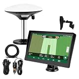
- Complete Tractor Guidance System: Includes stable software to guide tractor along AB lines, featuring a 7 inch waterproof navigator display with high-precision GNSS Board, high precision GNSS GPS Antenna, and all necessary accessories cables and tools
- Smart GNSS Guidance & AB Line Planning: Generates straight AB lines or curve paths based on your field boundary and working width, records driving tracks and provides real-time deviation alerts to keep passes straight at night or in low visibility conditions
- Multi-Frequency Positioning (L1L5): Large 7 inch screen displays guidance lines, field boundaries, and tractor position in real time. The L1L5 multi-frequency module delivers higher accuracy and more stable signals than single-frequency GPS, keeping every pass on track even near trees or buildings. The device needs to be connected to either a cell phone hotspot or a personal mobile network
- Wide Application Compatibility: Tractor GPS navigation system can be widely used for sowing, cultivating, trenching, ridging, spraying pesticide, transplanting, land consolidation, harvesting and other work scenes. Suitable for John Deere, Case IH, New Holland, Massey Ferguson, Fendt, Kubota, and most tractors. Suction-cup tablet bracket mounts on cab window with no drilling required. Swap between machines in approximately 3 minutes
- Google Maps & 48 Languages: Built on Google Maps for use in most regions worldwide, suitable for international farms or contractors. 48 language options let operators work in their native language, reducing training time and errors
Variable-depth tillage and the compaction question
Variable-depth tillage aims to work only as deeply as needed in a particular zone. Potential inputs include soil texture and electrical-conductivity maps, elevation, yield history, traffic lanes, root observations and compaction measurements. The core agronomic question is whether there is a persistent, yield-limiting constraint at a known depth. Spatial variation on a map by itself does not prove that tillage is needed.
Compaction can result from wet-field traffic, heavy axle loads or repeated passes, but naturally dense soil and dry soil can also resist a probe. Penn State Extension cautions that penetrometer readings are not meaningful in dry soil; it recommends testing after the profile has been thoroughly wetted for roughly 24–48 hours and confirming readings by examining roots and soil. If a compacted layer is diagnosed and subsoiling is justified, its guidance says to set the tool about 1–2 inches below that layer. Its estimate of at least 50 horsepower per shank is a planning figure, not a universal requirement; depth, moisture, soil and shank design change draft needs. See Penn State’s subsoiling guidance and its overview of compaction effects.
Deep tillage can loosen soil temporarily, yet yield benefits are inconsistent in many Upper Midwest conditions and depend on actual compaction, moisture, crop, weather and subsequent traffic. Soil loosened when wet may smear; soil worked when too dry can demand much more draft and fuel. If the cause is traffic, drainage or repeated wet operations, changing those conditions may be more durable than repeatedly ripping the symptom. University of Minnesota Extension summarizes these limits in its soil-compaction guidance.
Free tools Windows power users keep installed
One-click scans. No signup required.
Soil conservation: precision is not the same as protection
Reduced disturbance and retained residue can help limit erosion, but outcomes depend on slope, residue distribution, rainfall, drainage, crop rotation and management. Less tillage may conserve moisture in drier conditions, while in wetter or poorly drained regions it can leave soils cooler and wetter at planting. Residue can protect soil but may also complicate seedbed warming, hairpinning, emergence, pests, disease or nitrogen availability.
Rank #4

- WAAS GPS receiver
- Simultaneous GPS and GLONASS reception
- Up to 10 position samples per second
- Bluetooth connectivity to up to 5 devices
- Automatic route recording
Controlled traffic is another complementary practice: keeping heavy wheels on defined lanes can reduce the area exposed to traffic-related compaction. NRCS identifies Controlled Traffic Farming as conservation practice code 334 and provides standards and supporting material through its controlled-traffic resource. Tools such as RUSLE2 help assess erosion risk and tillage intensity, but neither a model nor a product label replaces field-specific planning. Consult NRCS practice standards and the applicable local guidance when conservation-program eligibility matters.
Independent reader supportYour contribution helps us test, update, and keep practical guides available for everyone.What precision tillage may change economically
Potential benefits include fewer overlaps, fewer unnecessary passes, better labor use, more consistent placement and more timely field operations. None is automatic. Guidance may reduce overlap without reducing the basic draft requirement of deep tillage, while a sensor or subscription adds cost without value if it does not change a decision or outcome.
Fuel figures are especially context-sensitive. In an Iowa State comparison summarized by University of Minnesota Extension for a specific 1,000-acre scenario, moldboard plowing plus spring field cultivation used 2,610 gallons of diesel, compared with 2,880 gallons for chisel plowing plus spring cultivation; the cited comparison also found strip-till used 34% less fuel than high-disturbance vertical tillage. These are study-specific results, not a forecast for a different farm. Implement design, row-unit count, soil, depth, field conditions and operator settings affect fuel use. Review the assumptions in the Extension’s tillage economics discussion.
What’s actually slowing this PC down?
Pick the symptom - the matching free tool is one click away.
Calculate total cost of ownership, not just the implement price. Include receivers and correction service, display and controller, implement-ready kits, hydraulics, sensors, software, installation, training, calibration, data labor, repairs, downtime, financing and depreciation. Also price the risk of an incorrect prescription or a missed operating window. Ask vendors for a farm-specific quote and verify compatibility rather than assuming a feature is included.
Best Value

- Built-in high-performance UBX-G7020KT multi-GNSS chip supports GPS, GLONASS, QZSS and SBAS, enabling fast and accurate positioning and obtain error-free NTP network time service. With official free GNSS software U-Center, it is easier to parsing the data of GPGGA, GPGLL, GPGSA, GPGSV, GPRMC, GPVTG and GPZD via PC, Laptop.
- Compatible: Win 11/10/ Win 8/ Win 7/Vista/XP/CE. Free GNSS Evaluation Software. 56-Channel All-IN-VIEW Tracking. Working process: Menu-> Receiver->Port or SensorAPI to get data from GPS Receiver after instialled GNSS software (Software can be downloaded from CD-ROM and Official website)
- Support OpenCPN, Kali Linux, Realtime Google-Earth Pro and maps. WIth the USB to type c converter, it fits Andriod phone/tablet. ( need to install GPS tools apps, like GNSS Master)
- With a magnetic base, it is convenient for installation and fixation anywhere., High sensitivity and Strong Singal,Protocol: NMEA 0183, ASCII and TTL stardard. Customizd navigation rate 1-10 hz.
- Cable Length 6.5 Ft / 2 Meters , IPX4 Water Resistance / Dust-tight. One-year after-sales service. Buy with confidence.
Autonomous tillage: a developing operating model
Autonomous tillage combines machine perception, automated controls, remote monitoring and operation software to reduce how much direct steering an operator performs. John Deere presents its autonomous-tillage workflow as a way to extend operating windows and allocate labor across tasks or machines. These are manufacturer-described benefits, not guaranteed farm-level results; consult its autonomous tillage overview for the vendor’s description.
Autonomy does not remove the need to check boundaries, manage obstacles and weather, maintain equipment, recover a machine, supervise safely or establish responsibility for damage. Field shape, connectivity, correction coverage, service support and compatible equipment affect suitability. Treat multi-machine supervision and labor savings as claims to validate with a pilot, not as assumptions in a purchase calculation.
A practical way to evaluate a system
- Name the problem. Is the bottleneck strip placement, residue distribution, overlap, a verified compacted layer or too many passes? Avoid buying technology without a defined job.
- Set a baseline. Record fuel, field time, passes, working depth, overlap, residue cover, planting quality, yield and repair costs.
- Diagnose before prescribing. Dig roots and inspect soil; use penetrometer readings only at suitable moisture and alongside other observations. Review traffic history, drainage and yield patterns.
- Compare less-disturbing fixes. Consider controlled traffic, tire-pressure management, lower axle loads, drainage, cover crops, rotation changes or shallower work before deep tillage.
- Get the fundamentals right. Verify boundaries, guidance lines, row spacing, implement width and offsets. Reliable positioning and data can be more valuable than advanced automation.
- Pilot representative zones. Where practical, leave untreated comparison strips. Check actual depth, strip alignment, residue and soil condition after the pass.
- Measure more than one season. Compare fuel, labor, capacity, emergence, yield, erosion indicators and maintenance costs. Scale only when results are repeatable.
Where the technology is heading
Likely areas of development include better residue and soil sensing, more responsive depth control, interoperable data workflows, coordinated machines and machine vision for autonomous field work. The useful test will remain whether these tools improve a verified agronomic decision and its execution. Fully autonomous, field-wide tillage that independently diagnoses what each acre needs should not be treated as routine today.
Outdated Drivers Are Slowing You Down
One free scan finds every outdated or missing driver and matches the right update for your exact hardware.Free scan · exact hardware matchPC Slower Than It Used to Be?
A free scan shows the junk files, broken settings and background clutter dragging Windows down - then fixes them in one click.Free scan · Windows 10 & 11The advancement of precision tillage is a shift from uniform disturbance toward selective, repeatable intervention. The strongest system is not necessarily the one with the most sensors or automation; it is the one that solves a real field problem with the least unnecessary soil disturbance at a defensible total cost.
Quick Recap
Product prices and availability are accurate as of the date/time indicated and are subject to change. Any price and availability information displayed on Amazon at the time of purchase will apply.

